Subject: China, Korea & Japan
Period: 1676 (published)
Publication: Introductionis in Universam Geographiam
Color: Hand Color
Size:
9.8 x 7.1 inches
24.9 x 18 cm
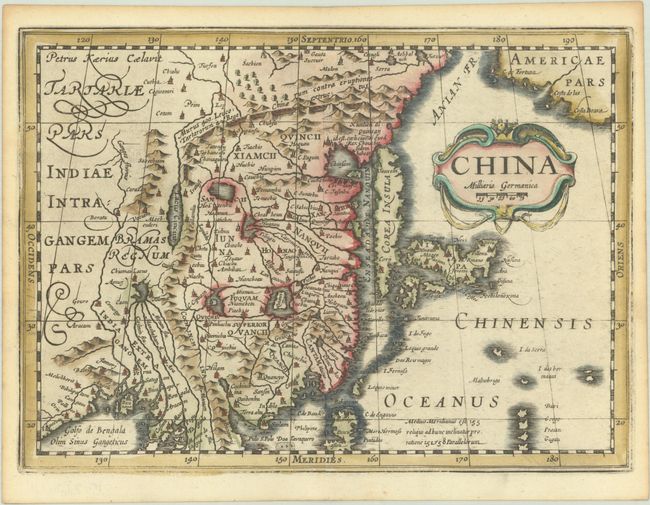
This finely engraved map of the region is based on the 1606 folio map by Jodocus Hondius and first appeared in 1630 in Cloppenburg's medium-sized atlas. The eastern part of China (bounded in the north by the Great Wall) is dominated by several large lakes and major rivers. The mythical Chiamai Lacus is depicted with five rivers branching off from it to the south. Korea is depicted as a strangely shaped island (later states show it as a peninsula). Below the strapwork title cartouche is Japan on the Ortelius-Teixeira model. Americae Pars appears in the upper right corner separated from Asia by a narrow Anian Strait. This is the second state of Cloppenburg's map, with most of the hatching in the sea erased and "Malnobrigo" changed to "Malnobrige." Engraved by Petrus Kaerius. Blank verso. Originally published in Johannes Cloppenburg's Atlas sive Cosmographicae (1630-36), this example appeared in an edition of Cluver's Introductio in Universam Geographicam.
Cluver's Introductio in Universam Geographicam was a popular atlas, appearing in over 45 editions during a 100-year period. The first edition was published without maps in the 1620s, and the first edition to include maps was published circa 1641. The various editions were published in different cities throughout Europe, including Amsterdam, Nuremberg, and London, often with new sets of maps engraved. This map is from an Amsterdam edition published by Jansson's heirs, which included some maps from Jansson's Atlas Minor.
References: Caboara #22; Shirley (BL Atlases) T.CLUV-6a #34; Van der Krogt (Vol. III) #8410:353.1.
Condition: A
A generally nice impression that is a bit weak along the neatline, with light toning along the edges of the sheet.