Subject: Arabia
Period: 1652 (dated)
Publication: L'Asie en Plusieurs Cartes Nouvelles, et Exactes
Color: Hand Color
Size:
9.6 x 7.5 inches
24.4 x 19.1 cm
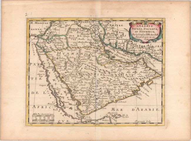
Beautiful, detailed map focused on the Arabian Peninsula filled with many place names, such as Oman and Mecca. The region is divided into the three classic divisions, including Baharem, which is shown separated from Arabia Deserte. Yemen (Hyaman) is noted across the entire Arabian Peninsula. Much of the cartography is spurious with several mountain ranges delineated. The map is graced with a strapwork cartouche. This is the first state, engraved by A. Peyrounin.
Sanson's small maps from his L'Asie en Plusieurs Cartes..., which were first published in 1652 and engraved by A. Peyrounin, were copied several times by various map publishers. Johann David Zunners made copies of Sanson's maps for his German translation of Die Gantze Erd-Kugel in 1679. Johannes Ribbius and Simon de Vries published copies in 1682 and 1683, with new maps engraved by Antoine d'Winter. The plates were later sold to Francois Halma, who used them in 1699 and then again in 1705 with the titles re-engraved in Dutch. The titles on the d'Winter plates were re-engraved back into French, and then used by Nicholas Chemereau in 1715 and by Henri du Sauzet in 1738.
References: cf. Ankary #85; Pastoureau, SANSON III A [6]; Tibbetts #97.
Condition: A
A nice impression with contemporary outline color in the map and later color in the cartouche, on a sheet with a bunch of grapes watermark. There is marginal soiling and minor toning that is more pronounced along the edges of the sheet.