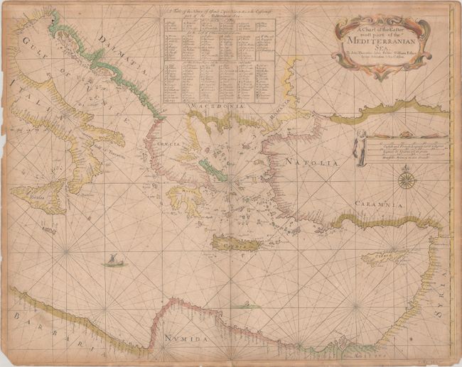
Subject: Eastern Mediterranean
Period: 1677 (circa)
Publication:
Color: Hand Color
Size:
21.5 x 17.1 inches
54.6 x 43.4 cm
This chart was published by the short-lived publishing partnership of John Seller, John Thornton, William Fisher, James Atkinson and John Colson. After initiating publication of The English Pilot, designed to compete with contemporary Dutch maritime atlases, John Seller ran into financial difficulties and enlisted the help of partners to complete his multi-part atlas. The partnership only lasted two years, so it is rare to find maps with all five names included. Although Seller was appointed Hydrographer to the King in 1671, this chart doesn't mention the distinction. The charts included in Seller's The English Pilot and his Atlas Maritimus were constantly evolving, and therefore, various copies of the atlases rarely contain the same contents.
This chart depicts the Mediterranean from Sicily in the west to Cyprus and the Holy Land in the East. The coastlines are filled with place names, and dozens of tiny islands, capes and havens are identified in a table at top. The map is adorned with a sailing ship, sea monster, compass rose, putto, and two strapwork cartouches. A very rare chart, of which we have found no other examples on the market over the last 30 years.
John Seller was a pioneering British publisher of nautical charts and one of the most important figures in the early history of British cartography. Seller's shop, located near the Tower of London in Wapping, became a gathering place for seamen arriving with the latest news of distant places such as the West Indies and provided Seller with information critical to his nautical chart business. In addition to sea charts he produced a vast array of cartographic material, the first to rival the large Dutch firms such as Blaeu and Jansson. Seller was appointed Royal Hydrographer by Charles II in 1671, and also served under James II and William III. Unfortunately his business was built on a shaky foundation and though he made several attempts to avoid bankruptcy including a consortium partnership with other cartographers such as William Fisher and John Thornton, he was ultimately unsuccessful.
References: Phillips (Atlases) #4150-14.
Condition: B
A nice impression with contemporary color on a moderately toned sheet with a fleur-de-lis watermark. There is light soiling, some small spots, and several chips along the edges of the sheet, with loss of the bottom left corner of the map. A few tiny tears along the edges of the sheet have been closed on verso with archival tape, and there are small remnants of hinge tape on verso.