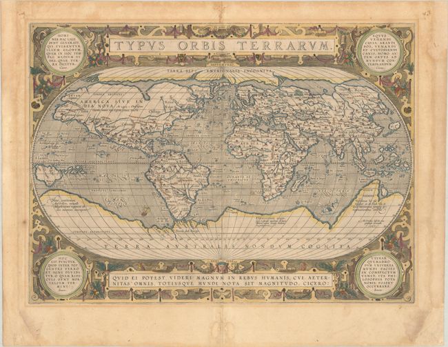
Subject: World
Period: 1587 (dated)
Publication: Theatrum Orbis Terrarum
Color: Hand Color
Size:
19.3 x 14.1 inches
49 x 35.8 cm
Ortelius' beautiful oval world map is a simplified version of Mercator's influential map of 1569. From surviving correspondence, it is known that Mercator encouraged Ortelius and provided him with information, particularly with coordinates of places in the Americas. This is the first state of Ortelius' third world map updated with the more correct shape of South America and the first depiction of the Solomon Islands off the coast of New Guinea. North America is nearly bisected by a lengthy St. Lawrence River, and the lands of Anian Regnum and Quivira are noted on the western coast. The Atlantic Ocean is filled with phantom islands, including Frieslant, St. Brandain, Brasil and many others. A huge Southern Continent incorporates Tierra del Fuego, and the mythical lands of Beach, Maletur and Lucach. The oval projection is surrounded by an intricate strapwork design with four corner medallions containing quotations from Cicero and Seneca. Spanish text on verso, published in either 1609 or 1612. Less than 10% of Ortelius' atlases carry Spanish text, making this a scarce and desirable edition of his world map.
References: Shirley #158; Van den Broecke #3.1.
Condition: B+
A nice impression on watermarked paper with several short centerfold separations closed on verso with archival material. The side margins have been extended with old paper to better accommodate framing. Also in the margins is some light toning, repaired chips in the bottom corners, and a pair of wormholes infilled at bottom center.