Subject: Poland
Period: 1626 (dated)
Publication: A Prospect of the Most Famous Parts of the World…
Color: Black & White
Size:
20.1 x 15.8 inches
51.1 x 40.1 cm
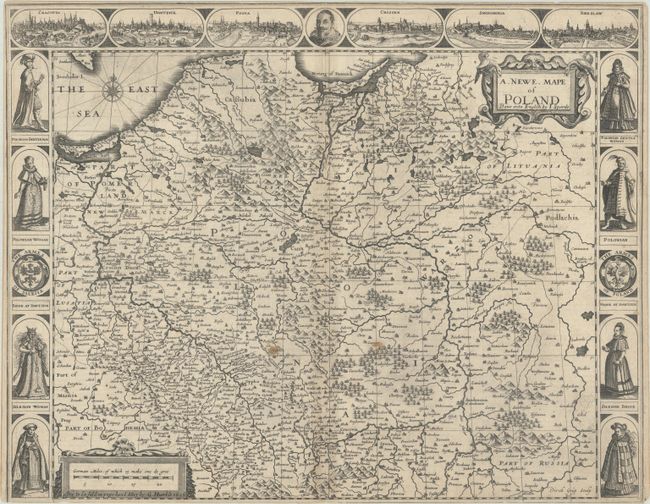
This beautifully engraved carte-a-figures map of Poland appeared in Speed's great English atlas. It extends from the Baltic (here called the East Sea) to Lviv and covers nearly all of present-day Poland. The map features excellent detail of towns and cities, rivers, forests, and mountains. Along the top of the map are six city views, showing Krakow, Gdansk, Poznan, Krosno Ordzanskie, Sandomierz, and Wroclaw, curiously omitting Warsaw, then the capital of the Polish-Lithuanian Commonwealth. In the center of the views is a portrait of a mustachioed figure, perhaps Sigismund III, the reigning King of Poland. On the sides are the coats of arms of Silesia and Poland, with an interesting array of local figures in traditional dress. The English text on verso has a generally warm appraisal of the Polish people: "The Inhabitants though they had but a wild beginning, yet in the more civill parts are of a gentle behavior to Strangers..." The map is further decorated by ornate title and distance scale cartouches. This is an early edition, as indicated by the publisher's imprint in the distance scale: Are to be Sold in pops-head Alley by G. Humble. 1626." Engraved by Dirck Gryp.
References: Shirley (BL Atlases) T.SPE-2a #16.
Condition: B
A dark impression on a sheet that was trimmed by the bookbinder with loss of the lower neatline and very narrow margins on the remaining three sides. There are a couple small stains near center, minor spots, light toning along the centerfold, and short centerfold separations at top and bottom.