Subject: World
Period: 1938 (published)
Publication:
Color: Printed Color
Size:
27.9 x 19.4 inches
70.9 x 49.3 cm
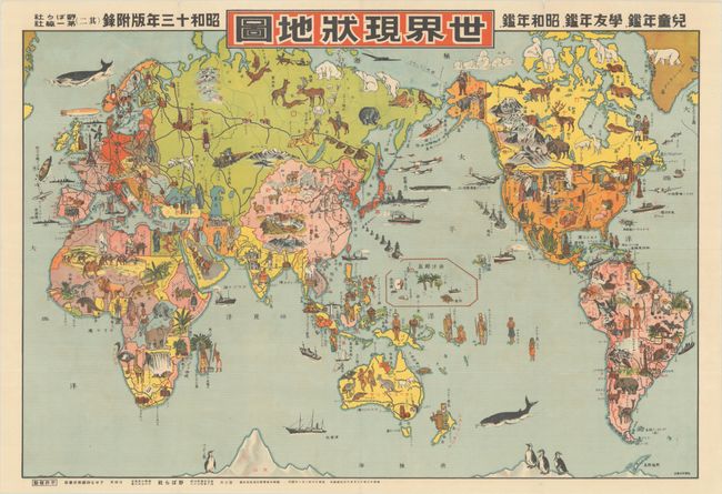
This fascinating and rare satirical map was published just prior to the start of World War II. The map is centered on the Japanese Empire, which is marked in red and includes Korea, Taiwan, and the Kuril Islands. (By the end of WWII, Japan would lose control of all three of these occupied territories.) The map is filled with colorful and whimsical cartoon ("manga") images that illustrate the local people, sites, flora, and fauna. There is a bison, Native American Indians in front of a teepee, and farmers in North America. The map is also filled with references to war, including war ships, planes and soldiers parachuting into eastern Russia.
This map was published in 1938, or Showa 13, at a time when Japan had renewed imperial ambitions yet political problems internally. This map clearly illustrates to a Japanese audience the assets and liabilities in each country around the world, with notations (in Japanese) throughout. This piece is an incredible snapshot of the Japanese world view just prior to WWII.
References:
Condition: A
Crisp and clean, issued folding, with a few tiny separations along the folds and two tiny chips along the top edge of the sheet.