Subject: World, Game
Period: 1930 (circa)
Publication:
Color: Printed Color
Size:
40 x 27.5 inches
101.6 x 69.9 cm
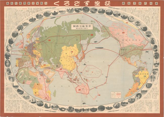
This decorative map of the world is used here as a Japanese Sugoroku board game, and was issued as a supplement to Osaka Mainichi Shinbun, a daily newspaper that is still in print today as Mainichi Shinbun. Players throw dice to determine how far along and which aviation routes to take in order to complete a journey across the world. The routes for the game are based upon flight paths of famous aviators including Lt. John Harding, Jr.'s aerial circumnavigation around the world in 1924, Charles Lindbergh’s solo transatlantic flight of 1927, and the Graf Zeppelin’s attempt in 1929. Countries are designated with their nation's flag, and only cities along the travel routes are identified. The oval map is surrounded by 52 images of important sites, people, and native animals that can be found around the world, such as the White House, New York City, Toronto, a Native American chief, a polar bear, and Hollywood silent movie actress Clara Bow. Text in the corners provide historical aviation facts as well as game instructions. Play begins at Osaka and ends when one player reaches Tokyo.
References:
Condition: B+
A bright example, issued folding, with light soiling and several small wormholes and a few tiny edge tears.