Current Auction
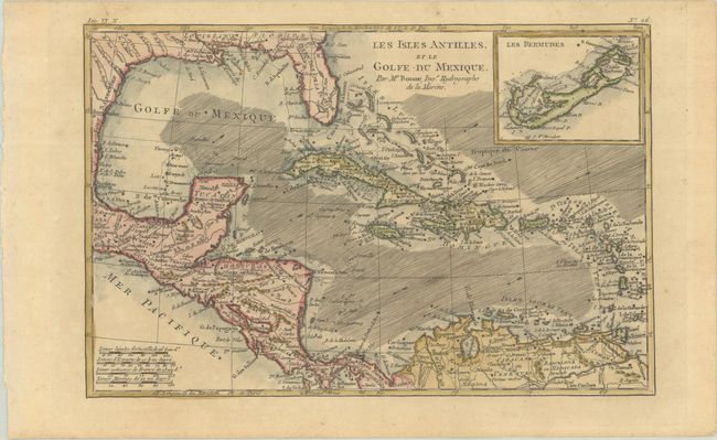
"Les Isles Antilles, et le Golfe du Mexique", Bonne, Rigobert
Subject: Gulf of Mexico & Caribbean
Period: 1780 (circa)
Publication: L'Histoire Philosophique et Politique…
Color: Hand Color
Size:
12.6 x 8.3 inches
32 x 21.1 cm
Download High Resolution Image
(or just click on image to launch the Zoom viewer)
(or just click on image to launch the Zoom viewer)
A beautiful and strongly engraved chart of the Caribbean that also features good detail of Central America. Along the Gulf Coast and Florida, New Orleans, Pensacola, and St. Augustine are named. Navigation routes, trade winds, rocks, and shoals are identified. An inset of Bermuda is located at upper right.
Rigobert Bonne was an important French cartographer of the late 18th century. In 1773 he succeeded Jacques Bellin as the royal cartographer in the office of the Hydrographer at the Depot de la Marine. Working in his official capacity, Bonne compiled some of the most detailed and accurate maps of the period.
References: Sellers & Van Ee #1705.
Condition: B+
A crisp impression on a lightly toned sheet with a few minor spots of foxing.
Estimate: $110 - $140
Current High Bid:
$0
Reserve: Reserve Not Met
Next Bid: $55
Bid Increments
$50 - $99$5
$100 - $249$10
$250 - $499$25
$500 - $999$50
Terms & Conditions