Current Auction
"Carte des Etats-Unis du Mexique", Lapie/Tardieu
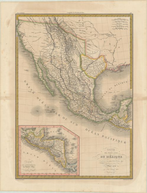
Subject: Southwestern United States & Mexico, Texas
Period: 1838 (dated)
Publication: Atlas Universel
Color: Hand Color
Size:
15.6 x 21.8 inches
39.6 x 55.4 cm
Download High Resolution Image
(or just click on image to launch the Zoom viewer)
(or just click on image to launch the Zoom viewer)
An attractive map that presents the Southwest and Mexico with an inset of Central America. The map also prominently depicts the Republic of Texas in its smaller configuration with southern boundary on the Nueces River. The El Camino Real is delineated through the heart of the Republic with many settlements to its east including Liberty, Washington, Columbia, Braxoria, and more. San Felipe is shown as the capital on the map, though it was actually in Houston (1837-39) at this time. Further to the west, the Rocky Mountains are well delineated by hachure and incorporate information from Humboldt, Pike, and Long. The cartography also predates Fremont and Smith’s explorations, including two Salt Lakes and the mythical rivers that connect them to the Pacific. The large blank area in the Great Basin is labeled Partie Inconnue (parts unknown). Above Texas, Arkansas is shown as a territory encompassing present-day Oklahoma despite it becoming a state in 1836. Engraved by Tardieu.
References:
Condition: B
Contemporary outline color with some light toning and color offsetting. Short centerfold separations confined to the blank margins have been closed on verso with archival tape. There are some minor creases in the lower right blank margin.
Estimate: $240 - $300
Current High Bid:
$120
Reserve: Reserve Not Met
Next Bid: $130
Bid Increments
$100 - $249$10
$250 - $499$25
$500 - $999$50
$1,000 - $2,499$100
Terms & Conditions