Current Auction
"Republic of Mexico", Wyld, James
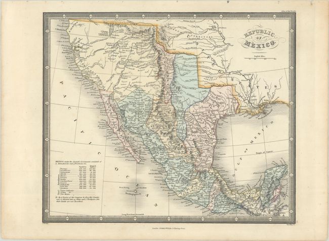
Subject: Southwestern United States & Mexico
Period: 1836 (circa)
Publication: Atlas of the World
Color: Hand Color
Size:
10.8 x 8.9 inches
27.4 x 22.6 cm
Download High Resolution Image
(or just click on image to launch the Zoom viewer)
(or just click on image to launch the Zoom viewer)
This early edition of Wyld's atlas map, later titled Republic of Mexico. And Texas, is considerably scarcer on the market. It covers the region from northern California south to Guatemala and delineates the political divisions of Mexico. Texas is named but not yet an independent republic, appearing south of the Red River as part of the Mexican intendancy of San Luis Potosi. San Antonio, Galveston, and Nacogdoches are among the cities named. New Mexico is a narrow strip with the Rio Grande running down the center and Santa Fe, Taos, and Albuquerque named. There is good detail of topography and the river system in the west, with two lakes in the Great Basin, L. Youtaw probably L. Timpanogos of the Spaniards and Salt Lake of Teguayo. The Buenaventura River flows from Teguayo to the Pacific, and the Sacramento River is shown with a partially conjectural course extending to the Pacific from L. Youtaw. Arkansas and Missouri territories are visible to the north, and the name N. Albion labels the region around Cape Mendocino. A table at bottom left shows the population and square miles of the 12 intendancies and 3 provinces of Mexico. The map is surrounded by a keyboard-style border. Engraved by Stockley.
James Wyld was successor to William Faden, one of the luminaries of late eighteenth century publishing in England. Wyld maintained the high standard of graphic and factual excellence that had been established by his predecessor, and his maps are among the finest published in the early nineteenth century. His Atlas of the World was first published in 1836, with several editions published through the mid-1860s.
References:
Condition: A
Full contemporary color with a couple faint spots.
Estimate: $160 - $190
Current High Bid:
$0
Reserve: Reserve Not Met
Next Bid: $80
Bid Increments
$50 - $99$5
$100 - $249$10
$250 - $499$25
$500 - $999$50
Terms & Conditions