Current Auction
Essential Map for Collectors of California and the American Southwest
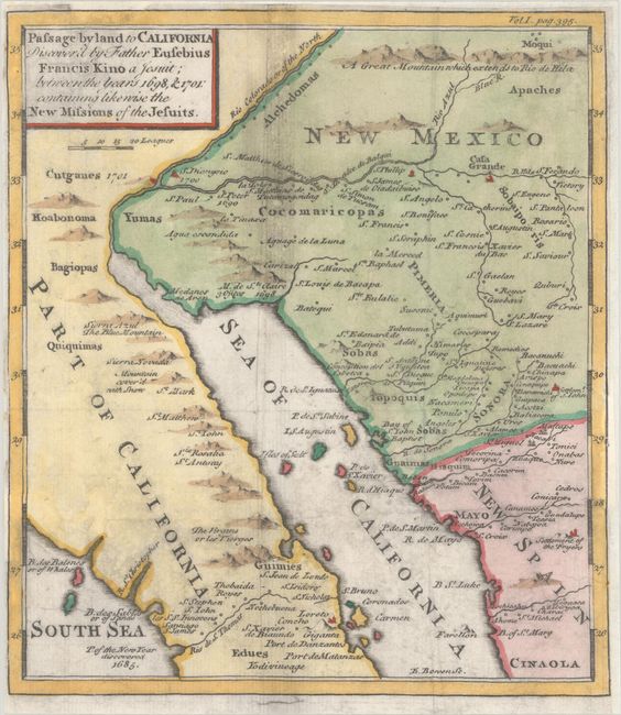
"Passage by Land to California Discover'd by Father Eusebius Francis Kino a Jesuit; Between the Years 1698, & 1701: Containing Likewise the New Missions of the Jesuits", Kino, Eusebio Francisco, SJ
Subject: Southwestern United States & Mexico
Period: 1762 (circa)
Publication: Travels of the Jesuits, Into Various Parts of the World...
Color: Hand Color
Size:
8 x 9.1 inches
20.3 x 23.1 cm
Download High Resolution Image
(or just click on image to launch the Zoom viewer)
(or just click on image to launch the Zoom viewer)
This is a later English edition of Father Kino's important map that disproved the theory that California is an island. It was the first map to accurately depict the region, in particular the relative positions of the Colorado and Gila rivers and the correct location of the rivers, valleys and mountains of part of Sonora and Arizona. Kino's publication, first issued in 1705, was intended to disprove the island theory, but instead actually fueled the controversy and thus the map was reprinted many times. Vol 1. pag. 395. is in the upper right border. Engraved by Emmanuel Bowen and published in John Lockman's Travels of the Jesuits, Into Various Parts of the World. An uncommon map that is essential to any collection of California or the American Southwest.
References: cf. Wheat (TMW) #89; cf. Wagner #483; cf. Schwartz & Ehrenberg plt. #75.
Condition: B+
Issued folding, now flat and backed with archival tissue to repair a few short edge tears and weaknesses in the paper. There is light printer's ink residue.
Estimate: $750 - $900
Current High Bid:
$500
Reserve: Reserve Not Met
Next Bid: $550
Bid Increments
$500 - $999$50
$1,000 - $2,499$100
$2,500 - $4,999$250
$5,000 - $9,999$500
Terms & Conditions