Subject: New Rochelle, New York
Period: 1963 (dated)
Publication:
Color: Printed Color
Size:
15.6 x 23.7 inches
39.6 x 60.2 cm
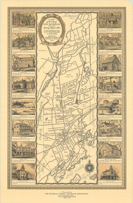
This map of New Rochelle was drawn by Herbert and Jerome Kates and published by the New Rochelle Federal Savings and Loan Associated in celebration of the city's 275th anniversary. Originally founded by the Huguenots in 1688, the map shows an evolved inner suburb of New York City some 17 miles from Midtown Manhattan. The map illustrates roads, railroads, and lakes with numerous small stars indicating points of historical significance including the Tory Headquarters during the American Revolution, Hessian soldier landing and camp, an Indian Quartz Mine, and numerous important buildings. Vignettes of 16 of these structures flank the map including City Hall, Besly's Tavern, Pintard Mansion, Thomas Paine Cottage, and Neptune House. The map is adorned by a decorative title cartouche, compass rose, and frame-style border. We found no past sales records for this map and only one institutional example on OCLC.
References:
Condition: A
Clean and crisp with a small chip in the top right blank margin.