Catalog Archive
Auction 208, Lot 219

"[3 Maps in Report] Map of Santa Monica and San Pedro Bays... [and] Location of Proposed Breakwaters in Santa Monica Bay... [and] Location of Proposed Breakwater in San Pedro Bay... [in] Deep-Water Harbor at San Pedro Bay", U.S. Corps of Engineers

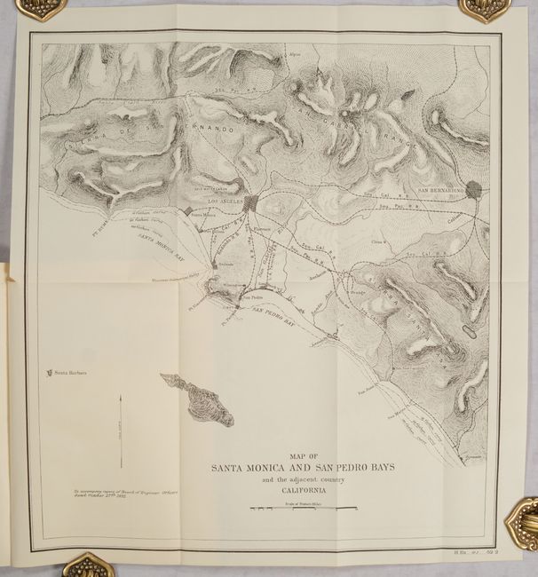
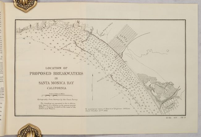
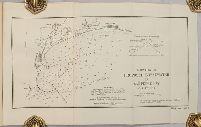
Subject: Los Angeles, California

Period: 1892 (published)

Publication: H.R. Ex. Doc. 41, 52nd Congress, 2nd Session

Color: Black & White

Size:
5.8 x 8.9 inches
14.7 x 22.6 cm
Download High Resolution Image
(or just click on image to launch the Zoom viewer)

A nice set of maps showing proposed internal improvements in the Santa Monica and San Pedro bays including:

A. Map of Santa Monica and San Pedro Bays and the Adjacent Country California (13.9 x 15.3"). Covers the coastline from Santa Monica south to Oceanside and east to San Bernardino. Cities are shown in street-grid pattern with lines of the Southern Pacific Railroad linking them together. Relief is well-developed and fathom lines are drawn in the waters along the coast.

B. Location of Proposed Breakwaters in Santa Monica Bay California (11.7 x 6.6"). Presents the street grid of Santa Monica and no development from there to the “Ballona Tract.” Numerous soundings fill the bay.

C. Location of Proposed Breakwater in San Pedro Bay California (13.1 x 6.8"). Shows Long Beach, Wilmington, San Pedro and detailed hydrography.

The maps are still bound into the original disbound 120-page report, which includes lengthy appendices of the testimony provided at a hearing and letters from interested parties. The Corps of Engineers recommended the San Pedro site (which ultimately was selected), but only after years of controversy and debate. For a brief article on the early history of the port and controversy, click here.

References:

Condition: A

Maps are fine, issued folding. Text has a hint of pleasant light toning. Disbound.

Estimate: $400 - $500

Sold for: $200

Closed on 4/22/2026

Archived