Current Auction
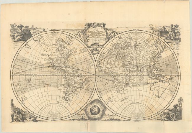
"A New & Accurate Map of All the Known World Drawn from the Latest & Most Authentic Surveys Assisted by the Best & Most Approved Modern Maps Charts &c. Wherein All the Late Discoveries & Improvemts...", Bowen, Emanuel
Subject: World
Period: 1747 (published)
Publication: A Complete System of Geography...
Color: Black & White
Size:
21 x 12.1 inches
53.3 x 30.7 cm
Download High Resolution Image
(or just click on image to launch the Zoom viewer)
(or just click on image to launch the Zoom viewer)
Vignettes of indigenous peoples representing Asia, America, Europe, and Africa surround this well-engraved double-hemisphere map. An attractive rococo title cartouche rests between the hemispheres. Only a few cities are named in North America, and the northwest coast is noted as Parts Undiscovered. Australia is misshapen and connected to Van Diemens Land with indistinct eastern and southern coastlines. New Zealand is mapped only on the west coast with no evidence of two islands. The Sea of Korea is identified, and Companies Land and De Gama's Land are located east of Japan. Crosshatched areas locate and show direction of trade winds. This is the state with the plate number "No. 4" engraved at lower left.
References: McCorkle (18th C. Geography Books) #17-2 (Vol I); Shirley (BL Atlases) T.BOW-2a #4.
Condition: B
A dark impression, issued folding on paper with a Lubbert van Gerrevink watermark. There are a couple of fold separations at bottom that have been backed with archival materials, light offsetting, and a few spots of foxing.
Estimate: $500 - $650
Current High Bid:
$0
Reserve: Reserve Not Met
Next Bid: $250
Bid Increments
$250 - $499$25
$500 - $999$50
$1,000 - $2,499$100
$2,500 - $4,999$250
Terms & Conditions