Subject: Mobile Bay, Alabama, Civil War
Period: 1866 (circa)
Publication:
Color:
This lot includes three Civil War maps depicting conflict in the Mobile Bay region between August 1864 and April 1865. The Mobile region was one of the last major battlegrounds of the Civil War and involved 4,000 Confederate troops and 16,000 Union troops.
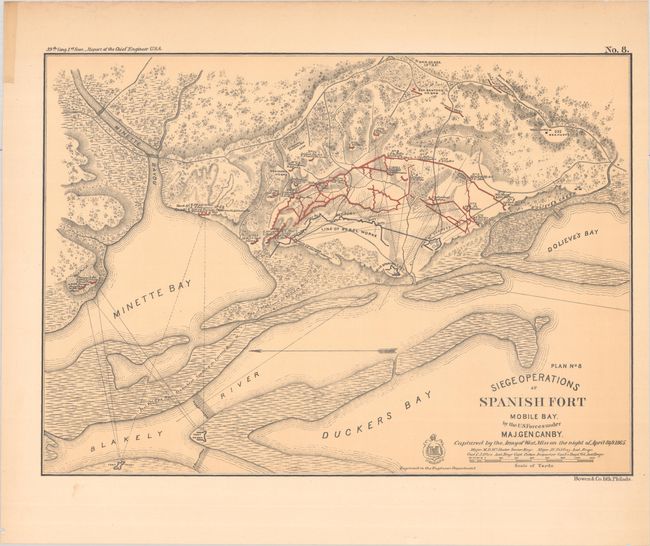
A. Siege Operations at Spanish Fort Mobile Bay. By the U.S. Forces Under Maj. Gen. Canby..., from Report of Chief Engineer U.S.A., 39th Congress, 1st Session, hand color (16.9 x 12.1"). This battle plan details the siege conducted by Union Maj. Gen. Canby on Spanish Fort from March 27 to April 8, 1865. Spanish Fort was the eastern defense of Confederate-controlled Mobile. Union and Confederate positions are highlighted in blue and red, and there is nice detail of roads, drainage, and topography. "Engraved in the Engineer Dept." Lithographed by Bowen & Co. in Philadelphia. Reference: Stephenson (CW) #112. Condition: On a slightly toned sheet with tape in the blank margin at top left. (B+)
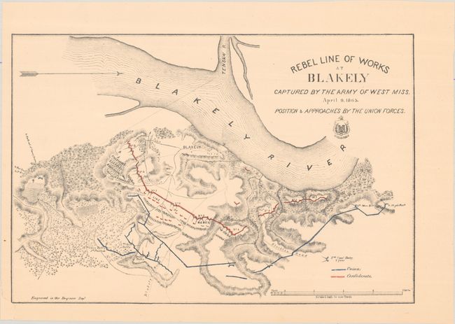
B. Rebel Line of Works at Blakely Captured by the Army of West Miss. April 9, 1965..., hand color (15.1 x 10.1"). This plan shows the Battle of Fort Blakely, the final major battle of the Civil War. As with the above map, Union and Confederate positions are highlighted in blue and red, and there is excellent detail of the landscape. "Engraved in the Engineer Dept." This is the first state; the second state was published in Report of Chief Engineer U.S.A., 39th Congress, 1st Session. Reference: Stephenson (CW) #104. Condition: A chip in the bottom left blank margin has been repaired with archival tape on verso. (A)
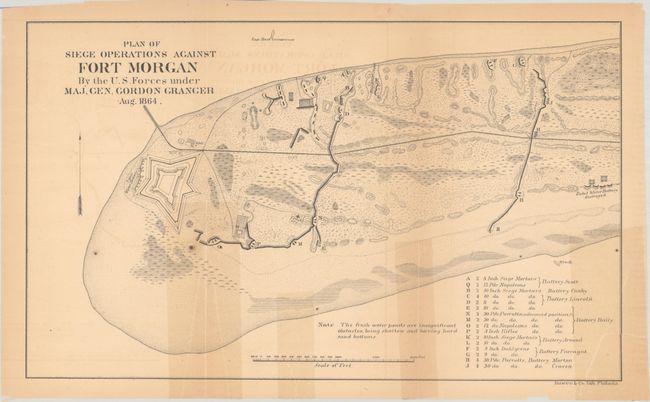
C. Plan of Siege Operations Against Fort Morgan by the U.S. Forces Under Maj. Gen. Gordon Granger Aug. 1864, black & white (12.8 x 7.8"). This map covers Fort Morgan during the Battle of Mobile Bay. The fort was besieged and fell under Union control on August 23, 1864. The fort is delineated, and the positions of batteries are identified with a key at bottom right. Lithographed by Bowen & Co. in Philadelphia. Condition: Issued folding on a lightly toned sheet with tape stains from repairs to separations on verso. There are a few spots and light offsetting. (B)
References:
Condition:
See description above.