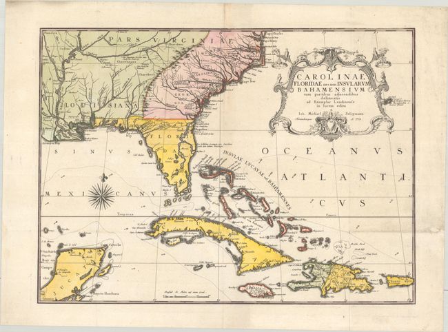
Subject: Colonial Southeastern United States, Bahamas & Greater Antilles
Period: 1755 (dated)
Publication:
Color: Hand Color
Size:
23.2 x 16.9 inches
58.9 x 42.9 cm
This handsome map extends to include the Bahamas, Cuba, Jamaica, Hispaniola, Puerto Rico, and the Yucatan. The map is from the German edition of Mark Catesby's Natural History of Carolina, a seminal work on American flora and fauna. The map depicts the southeastern United States as far west as the Mississippi River and is colored to show the British Colonies in pink, French possessions in green and the regions controlled by Spain in yellow. Catesby drew on several important maps for the content, including the manuscript of Captain John Barnwell (1722) that incorporates several details not found on earlier printed maps. He also used Popple's great 20-sheet map as seen by the river configuration in Georgia and the dotted trail connecting Fort Argyle to Combahee River. The top right corner is adorned with a gorgeous and elaborate title cartouche.
References: Cumming (SE) #292; cf. Schwartz & Ehrenberg pp. 151-152.
Condition: B+
A sharp impression with full contemporary color on a sheet with a coat of arms watermark. Issued folding and now flat with archival repairs to a few short fold separations around the lower horizontal fold and some minor soiling at right.