Subject: United States, Railroads
Period: 1890 (circa)
Publication: Seventh Annual Report of the Trade and Commerce of Minneapolis
Color: Printed Color
Size:
36.8 x 17 inches
93.5 x 43.2 cm
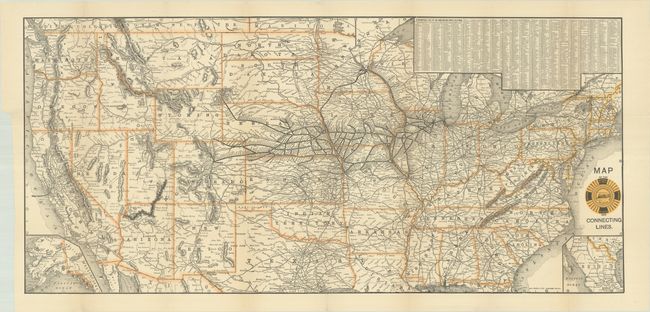
This scarce and detailed railroad map shows Burlington Route in bold black lines, spanning from Chicago to the Black Hills, Cheyenne, and Denver. Other connections and railways are delineated with thinner black lines. North Dakota is depicted in a compressed configuration. At bottom left, an inset extends coverage to Alaska, and another inset at bottom right shows southern Texas and Mexico. An alphabetical table of Burlington Route stations appears at top right. The title incorporates a striking railroad logo with a train at center surrounded by a track and a list of various destinations. Published in Seventh Annual Report of the Trade and Commerce of Minneapolis for the Year Ending December 31, 1889.
References:
Condition: A
Issued folding with a short archivally repaired binding tear that just enters the image at top left.