Subject: United States
Period: 1860 (circa)
Publication:
Color: Hand Color
Size:
16.8 x 10.8 inches
42.7 x 27.4 cm
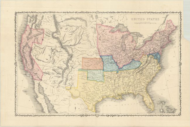
This terrific map covers the entire country, issued just prior to the beginning of the Civil War, which is the main focus of the map. The map uses color to indicate federal non-slaveholding states (pink), states bordering slave states (blue), and the Confederate states (yellow). Indian Territory is green and Kansas is orange, perhaps suggesting that the map predates Kansas's statehood. This example differs from other examples that we have seen in that there is no color key below the title and Kansas is not colored as a free state. The large Washington Territory, is depicted in the short-lived inverted 'L' configuration, extending east to the Continental Divide and south to the Utah Territory. The proposed Territory of Arizona is shown in the southern part of New Mexico Territory. A huge Dakota Territory extends from Minnesota to Washington. Surrounded by a decorative vine and leaf border. An uncommon pre-Civil War issue that was published by the London Printing and Publishing Company.
References:
Condition: A
Issued folding with full contemporary color. There is a binding trim at top right with a 0.5" fold separation that has been closed on verso with archival tape.