Subject: United States
Period: 1854 (dated)
Publication: The Progress of the United States of America...
Color: Hand Color
Size:
27.3 x 16.8 inches
69.3 x 42.7 cm
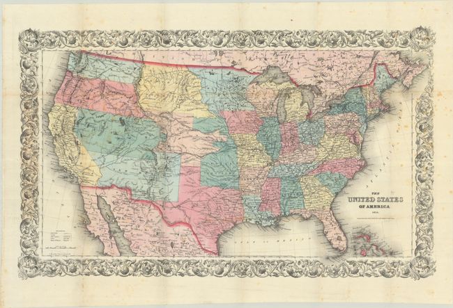
This uncommon and interesting map depicts the American West in a period of transition, showing a pre-Gadsen Purchase border and several early western territorial boundaries. The map predates the Kansas-Nebraska Act and the creation of Kansas Territory. Therefore, Indian Territory shares a bizarre, uneven border with Nebraska, which appears in a dispersed blob-like configuration. Washington and Oregon Territories extend to the Northwest Territory at the continental divide. The Northwest Territory in turn extends to the Missouri River where it borders a large Minnesota Territory. Utah Territory spans from California east to join Nebraska Territory along the Rocky Mountains and Continental Divide. The very large New Mexico Territory comprises all of today's Arizona and part of Colorado. The map details the exploration routes of many expeditions including those of Marcy, Kearny, Fremont, etc., and locates the Santa Fe trail. Surrounded by an ornate border. Printed on banknote paper by D. McLellan. Originally issued as a pocket map in 1853, this edition is updated with a 1854 date below the title. It appeared in an updated, reduced form in several Colton atlases.
References: cf. Rumsey #4814.
Condition: B+
Issued folding with contemporary color. There is light foxing and a few minute separations at fold intersections that have been repaired on verso with archival tape.