Subject: United States, Texas & Mexico
Period: 1844 (dated)
Publication: Olney's School Geography
Color: Hand Color
Size:
17.4 x 10.5 inches
44.2 x 26.7 cm
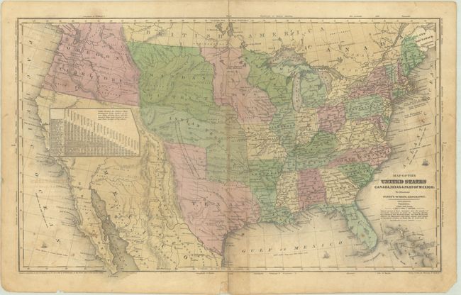
This map prominently features the Independent Republic of Texas in its last full year as a republic. The panhandle extends well to the north. Austin is the settlement furthest to the west with many other towns named to the east including Houston, San Antonio de Bexar, and Columbus. To the west is a small region named Santa Fe or New Mexico. The huge Indian Territory to the north extends up to the Mandan District. The large area of the "American Desert" is shown mostly in Indian Territory, but extends into the panhandle of Texas. Mexico controls California and the Southwest, which is labeled Mexico, while the Baja is Old California. A large table of distances obscures much of northern California. The huge Oregon Territory reaches to the Continental Divide and well north into British America as part of the 54°50' or Fight controversy with England. East of Oregon is the large Mandan District that extends to an oversized Iowa at the Missouri River, that in turn extends to Wisconsin at the Mississippi River. The map has terrific territorial configurations and is filled with information on forts, Indian tribes, waterways and more. Copyright below neatline by D.F. Robinson. Drawn and engraved by Sherman & Smith, N.Y.
References:
Condition: B
Contemporary color with light offsetting, some soiling and staining, and a 1.25" centerfold separation at bottom that has been closed on verso with archival tape.