Subject: United States, Exploration & Surveys
Period: 1758 (published)
Publication:
Color: Black & White
Size:
4 x 6.8 inches
10.2 x 17.3 cm
This is a nice example of volume fifty-five from Prevost's history of voyages, with maps by Jacques Nicolas Bellin. This is the 1758 edition, published by Firmin Didot in Paris. The focus of this volume is the United States, and includes five fold-out maps and three full-page engravings. The maps include:
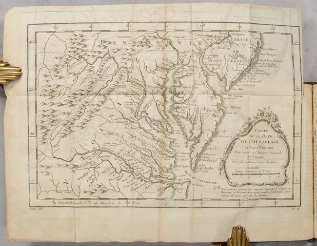
A. Carte de la Virginie, de la Baye Chesapeack, et Pays Voisins. This map covers most of Virginia, Maryland, and Delaware with a bit of Pennsylvania and New Jersey. The interior is fully engraved with mountains and great detail along the rivers. An early network of trails and wagon roads connects the communities along the seaboard and stretches as far west as Frederic Town ou Winchester, with one road continuing further southwest. Fort Cumberland, Bukingham, and many frontier villages are located. Condition: There is moderate offsetting, a short binding tear at right, and light toning along the sheet edges. (B)
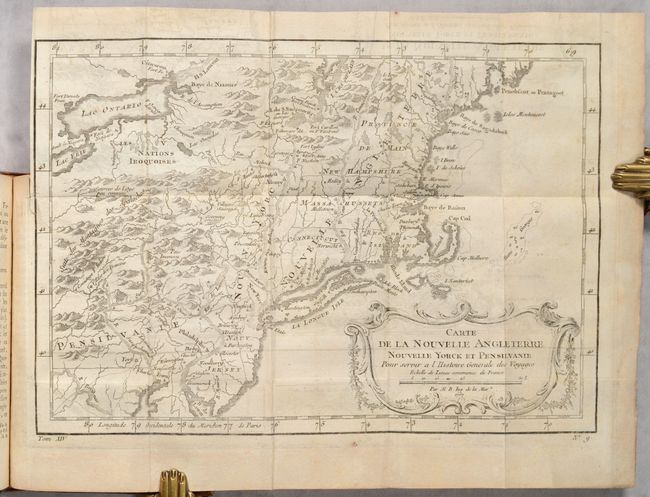
B. Carte de la Nouvelle Angleterre, Nouvelle Yorck, et Pensilvanie. This French & Indian War period map details the English colonies from Pennsylvania through Penobscot Bay in Maine, with their early boundaries. It is fully engraved with topographical features and includes many early place names. The colonies are shown confined east of the Allegheny Mountains with the Nations Iroquoises, Indian villages, and several French forts located west of the mountains. It extends to show Lake Ontario and most of Lake Erie. Condition: There is moderate offsetting, a short binding tear at left, and light toning along the sheet edges. (B)
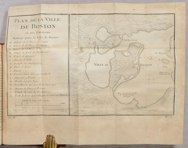
C. Plan de la Ville de Boston. Attractive early plan of Boston and the harbor including Charles Town and Isle Ronde. It shows the street plan of the town and wharves, and locates gun batteries, powder magazines, Presbyterian churches, prison, town hall, windmill, and beacon. It indicates an offshore anchorage and the entrance channel and also depicts shoreline topography with the roads running down to the harbor. Large key at left lists sixteen important sites. Condition: On a lightly toned sheet with some minor offsetting. (B)
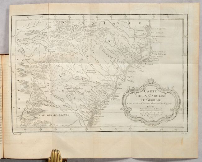
D. Carte de la Caroline et Georgie. Delicately engraved map of the colonies of Carolina and Georgia from Albemarle Sound to the Alatamaha River. It probably owes its origin to the 1752 map of the region by Emanuel Bowen. There are numerous English settlements along the coast and Indian villages are located throughout, including a number west of the Appalachian Mountains. There is more detail in the area west of the Blue Ridge than in many other maps of the period. It shows a rudimentary course of the Tennessee River in the northwestern section of the map. Condition: Light offsetting. (B+)
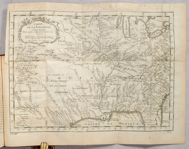
E. Carte de la Floride, de la Louisiane, et des Pays Voisins. Finely engraved and detailed map of French Louisiana that extends from the Great Lakes and Michigan to the Gulf of Mexico and from Nouveau Mexique to the middle of Florida. The Mississippi River flows dramatically down the center of the map with tributaries including the Ohio River, (l'Oyo ou la Belle), Missouri River, and the Riviere de Moingona in the area of modern-day Des Moines. Locates Santa Fe, Apache tribes and an early reference to Texas as Pars des Cenis. The map is filled with many Indian names, missions, forts and early settlements. Early explorations are noted including la Salle en 1685 in today's Texas. Condition: Moderate offsetting. (B)
564 pages. Hardbound in full contemporary leather with gilt tooling and title on red leather label on spine. There are marbled end-papers and the original ribbon page-marker.
References:
Condition:
See description for individual map condition/grades. Text is lightly toned with an occasional spot of foxing. Covers have light wear along with some minor cracking of the spine. Text/Binding (B+)