Subject: Northeastern United States & Canada, Great Lakes
Period: 1783 (dated)
Publication: Atlas Geographique...
Color: Hand Color
Size:
25.6 x 19.7 inches
65 x 50 cm
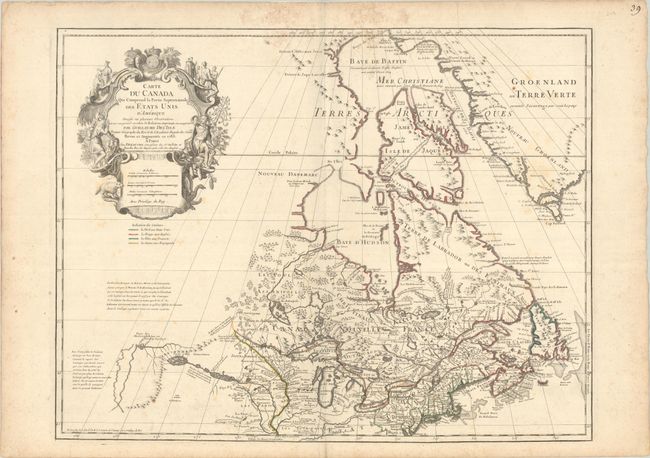
First issued by Guillaume Delisle in 1703, this richly detailed map provides the most accurate rendering of the Great Lakes of the time, with the lakes fully enclosed and properly placed in longitude and latitude. Delisle's map of Canada and the Great Lakes is one of the most outstanding and influential maps of the eighteenth century. This particular edition is notable as being the first to name the United States and features a color-coded legend defining possessions beneath the title cartouche. Cartographically, the map correctly positions the Ohio River but confuses its name with the Wabash River. West of the Mississippi, Lahontan's fictitious Riviere Longue is prominently depicted. In Canada, special attention is given to the rivers and lakes between Hudson Bay and the St. Lawrence, and Lac de Assenipoils (Lake Winnipeg) connects to Hudson Bay. Sanson's three islands of the Arctic are retained. The exquisite cartouche is decorated with a beaver, natives (one of whom is bearing a scalp), and Jesuit explorers. This is the eighth state of the map.
References: Kershaw #315; Tooley (Amer) #42, p. 21.
Condition: B
Contemporary outline color on a sturdy sheet with a watermark of a Maltese Cross encircled in rosary beads. There is some light scattered foxing, dampstains that just enter the border at top, and several short archivally repaired edge tears confined to the blank margins.