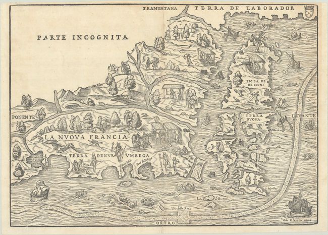
Subject: Colonial Northeastern United States & Canada
Period: 1565 (published)
Publication: Terzo Volume delle Navigationi et Viaggi
Color: Black & White
Size:
14.6 x 10.6 inches
37.1 x 26.9 cm
This unusual map is the first to focus on the area of New England and New France and the first to use the name Nuova Francia. Derived from Gastaldi's 1548 regional map, the cartography is based largely on Verrazzano and Cartier's reports resulting in a curious depiction of the Hudson and St. Lawrence rivers. Newfoundland is identified as Terra Nuova, below the large Isola de Demoni, appropriately decorated with demons. The area near New York Harbor is titled Angoulesme. Long Island, which Verrazzano imagined as a peninsula, is labeled Flora. Newport Bay is called Port Real and Narragansett Bay is Port du Refuge. A long, snake-like band, speculated to be an early representation of the Gulf Stream, marks the rich fishing banks. The map is populated with scenes of Native Americans hunting and fishing, elaborately engraved ships, and fanciful sea monsters. This example is the second state, as evidenced by the addition of weeping willow trees.
References: Augustyn & Cohen, pp. 18-19; Burden #25; Goss (NA) #8; Kershaw #15a; McCorkle #556.1; Mickwitz & Miekkavaara #641 Vol. III #4; Sabin #67741; Shirley (BL Atlases) G.RAMU-2a #5; Verner & Stuart-Stubbs #2.
Condition: B+
A crisp impression on a bright sheet with a hint of toning along the top border. There are professional repairs to a 2.25" edge tear at bottom and a 1.5" centerfold separation at top. The page numbers in the top margin have been trimmed away, but there is still adequate room for framing.