Subject: World
Period: 1651 (dated)
Publication: Cartes Generales de Toutes les Parties du Monde...
Color: Hand Color
Size:
20.7 x 13.9 inches
52.6 x 35.3 cm
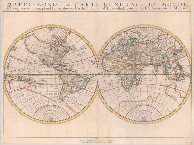
This is the first state of Sanson's first map of the world, showing California as an island. It is one of the first maps to distinguish the Great Lakes and name Lac Superieur and Lake Michigan, here called Lac des puans (lake of evil smells). All five of the Great Lakes were not named until Sanson's 1656 map of New France. The northwest coast of North America extends far west to Asia, with the place names Anian, Quivira, Nouvelle Albion, and Sierra Nievada. The faint outline of Terra Magellanica appears in the south. Australia is only partially shown, and labeled simply Beach, with place names on the south and west coasts reflecting Dutch discoveries. Neither Tasmania nor New Zealand are shown. The map is typical of Sanson's "scientific" style of cartography with no decorative elements. It was published in conjunction with Pierre Mariette (father and son), who published many of Sanson's works after 1645. Engraved by Riviere.
References: Pastoureau, SANSON V A [1]; Shirley #390.
Condition: B+
A crisp impression on a sheet with an elaborate coat of arms watermark. Professionally remargined at the sides, with loss of about 2mm of the image at right with the neatline replaced in facsimile at right. There are additional professional repairs to an edge tear and chip in the title, with loss of the semicolon from title at top right.