Subject: Colonial North America
Period: 1781 (dated)
Publication: Atlas Portatif...
Color: Hand Color
Size:
12.6 x 8.4 inches
32 x 21.3 cm
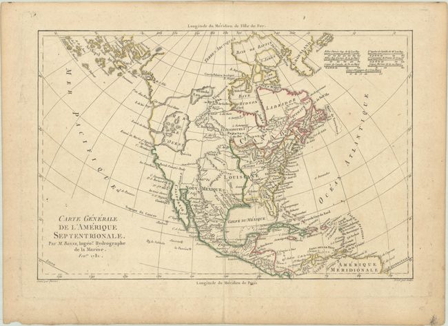
This is the less common edition of Bonne's map of North America displaying some of the most intriguing cartographic mismapping of the late eighteenth century. The most apparent deviation is the huge Mer de l' Ouest, complete with several fictitious islands and the fabled wealthy city of Quivira on its southern shore. This sea is connected to the Pacific by the Entree of Jean de Fuca and the Entre de Martin d'Aguilar. In the middle of Canada is a gigantic Grande Eau from which flows the mythical R. de los Reyes (a remnant of the Northwest Passage theories). Also striking is the treatment of Alaska, shown as a vast group of islands, the most prominent of which is named Alaschka. Longitude is measured from Paris on lower scale and from I'Isle de Fer on the upper scale. Seven distance scales fill the top left corner.
Rigobert Bonne was an important French cartographer of the late 18th century. In 1773 he succeeded Jacques Bellin as the royal cartographer in the Office of the Hydrographer at the Depot de la Marine. Working in his official capacity, Bonne compiled some of the most detailed and accurate maps of the period.
References: McGuirk #180.
Condition: B+
Contemporary outline color on a lightly toned sheet.