Subject: References, Blaeu & Visscher, Wall Maps
Period: 1996 (published)
Publication:
Color: Black & White
Size:
20.6 x 16.2 inches
52.3 x 41.1 cm
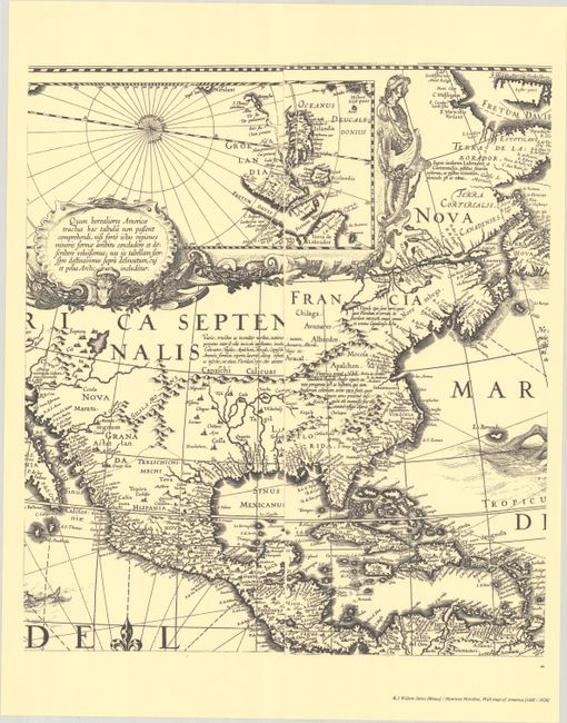
This is the fifth volume in this incredible series on the history of cartography. Volume V covers 10 important and highly decorative wall maps by Dutch masters Willem Jansz Blaeu and the Visscher, including Blaeu's maps of the continents and both Blaeu and Visscher's maps of Germania and Holland. Most of these maps were produced during the Twelve Years' Truce (1609-21), a prosperous and productive ceasefire in the Eighty Years' War between the Dutch Republic and Spain. It provides a superb carto-bibliography of the most decorative wall maps from the Dutch Golden Age. Text volume in both Dutch and English, 384 pp., profusely illustrated, together with the portfolio containing full-size facsimile reproductions of 10 maps on 145 sheets (the contents erroneously list 142 sheets). The maps reproduced in the portfolio include Blaeu's maps of Europe, Asia, Africa, and America (14 sheets each); Visscher's map of Germania (19 sheets); Blaeu's map of Germania (16 sheets); Blaeu's map of Holland and West-Friesland (11 sheets); Visscher's map of Holland and West-Friesland (18 sheets); Blaeu's map of Italy (16 sheets); and Blaeu's map of Flanders (9 sheets). Hardbound in blue cloth with gilt embossed titles.
References:
Condition: A
Map facsimiles are crisp impressions, with some slightly creased corners. Text is clean and tight. Text volume and portfolio have minor shelf wear to covers, and hinge is starting on portfolio.