Subject: Western Hemisphere - America
Period: 1725 (circa)
Publication: Altdorfini Atlas Manualis Scholasticvs…
Color: Hand Color
Size:
13.6 x 10.9 inches
34.5 x 27.7 cm
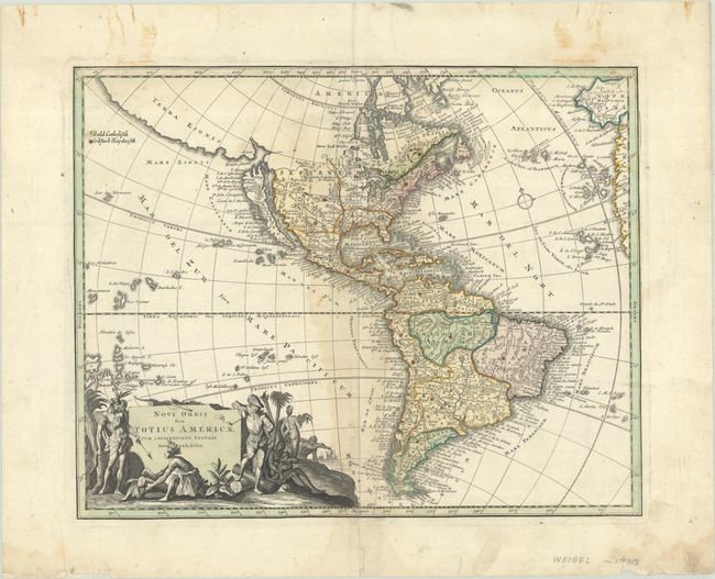
This attractive map of the Americas features California as an island. Across the narrow strait, Fretum Aniani, is the kingdom of Anian and the large stretch of coastline noted as Terra Esonis. North America includes many interesting misplaced place names and cartographic errors: Louisiene and Apaches de Novajo appear to the northwest of the Great Lakes; two rivers flow past Santa Fe - one (R. del Norto) empties into the Gulf of California and the other (Magdalene Fl) flows in the approximate path of the Rio Grande and empties into the Gulf of Mexico; the Mississippi River delta is too far west; and a large lake appears in Carolina. Embellishing the southwest corner of the map is a title cartouche featuring Indians, a pipe-smoking European, and several slaves. This example has old manuscript additions noting areas that are Catholic (noted as gold but appears green) and Pagan (beige).
References: McLaughlin #204; Tooley (Amer) p. 132 #90.
Condition: B
Contemporary color on a watermarked sheet with dampstaining primarily along the centerfold and some manuscript additions. There are additional stains in the margins as well as a couple of short repaired centerfold separations.