Subject: Africa
Period: 1676 (published)
Publication: Introductionis in Universam Geographiam
Color: Hand Color
Size:
9.8 x 7.1 inches
24.9 x 18 cm
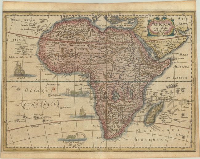
This fine map details the entire continent of Africa with Madagascar and the Arabian Peninsula. Although Jodocus Hondius is credited as the source for this map in the title, the map actually follows more closely the work of Willem Blaeu's map of 1617 and Jodocus Hondius Jr,'s maps of 1619 and 1623. Includes the hypothetical interior detail, which is typical of maps from this period. The Nile originates from two large lakes well south of the Equator. The map is embellished with a strapwork title cartouche and numerous sailing ships and sea monsters. Engraved by Pieter van den Keere for Cloppenburg's small Atlas, first published in 1630, and later used by Jansson's heirs for an edition of Philipp Cluver's popular series of geographical textbooks.
Cluver's Introductio in Universam Geographicam was a popular atlas, appearing in over 45 editions during a 100-year period. The first edition was published without maps in the 1620s, and the first edition to include maps was published circa 1641. The various editions were published in different cities throughout Europe, including Amsterdam, Nuremberg, and London, often with new sets of maps engraved. This map is from an Amsterdam edition published by Jansson's heirs, which included some maps from Jansson's Atlas Minor.
References: Betz #65; Shirley (BL Atlases) T.CLUV-6a #43; Van der Krogt (Vol. III) #8600:353.
Condition: B+
A lightly toned sheet with a paper flaw in the south Atlantic Ocean. Trimmed by the bookbinder to the neatline at top right and just within the neatline at top left.