Subject: Middle East
Period: 1626 (dated)
Publication: A Prospect of the Most Famous Parts of the World
Color: Black & White
Size:
20.3 x 15.5 inches
51.6 x 39.4 cm
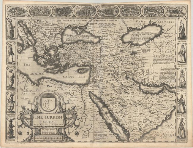
This splendid carte-a-figures map covers the region from Italy across the Middle East to include Persia and Arabia, the Black and Caspian Seas, and the Red Sea. Based on Hondius' map of the region, the interior is fully engraved with mountains, deserts, and numerous towns and villages. The Persian Gulf is labeled the Sea Elcatif sometimes the Arabian Gulfe. Included along the top are eight bird's-eye views of important cities including Damascus, Jerusalem, Constantinople, Rhode, Alexandria, Ormus and Famagusta. Along each side are five full portraits of Greek, Egyptian, Assyrian, Arabian, and Persian men on the left and their wives on the right. With numerous annotations in blank areas giving historical and geographical details. This edition has the imprint of George Humble, published between 1627-32. The English text on verso provides a fascinating contemporary description of the region. The spectacular title cartouche features the crescent moon and a crown.
References: Ankary #42; Potter (Antique Maps) p. 119; Tibbetts #77; Shirley (BL Atlases) T.SPE-2a #18.
Condition: A
A crisp impression on paper with a bunch of grapes watermark. There are a few printer's creases along the top centerfold and the top blank margin is narrow at center only. Two short tears in the bottom blank margin have been closed on verso with archival tape.