Subject: Florence, Italy
Period: 1575 (published)
Publication: La Cosmographie Universelle…
Color: Hand Color
Size:
14.4 x 9.1 inches
36.6 x 23.1 cm
Sebastian Munster (1489 - 1552) was one of the three most renowned cartographers of the sixteenth century, along with Mercator and Ortelius. Munster's Geographia and Cosmographia Universalis were two of the most widely read and influential books of the period. His editions of Ptolemy's Geographia, published between 1540 and 1552, were illustrated with 48 woodcut maps, the standard 27 Ptolemaic maps supplemented by 21 new maps. These new maps included a separate map of each of the known continents and marked the development of regional cartography in Central Europe. The antique geography was a prelude to Munster's major work, the Cosmographia, which was published in nearly 30 editions in six languages between 1544 and 1578 and then was revised and reissued by Sebastian Petri from 1588 to 1628. The Cosmographia was a geographical as well as historical and ethnographic description of the world. It contained the maps from the Geographia plus additional regional maps and city views with nearly 500 illustrations which made it one of the most popular pictorial encyclopedias of the sixteen century.
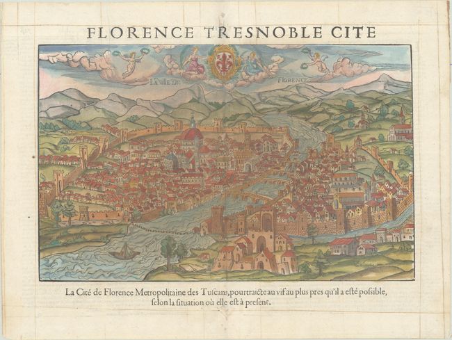
This attractive woodblock view of Florence appeared in the rare Belleforest edition of Munster's Cosmographia. It depicts the city situated on both sides of the river Arno and connected by four stone bridges. The many palaces and churches are well rendered, as are the medieval city walls. The Belleforest edition of the view combines the original engraving with the allegorical figures flying over the scene with the red iris coat of arms from the Petri edition. He also adds an alternate title, La Ville de Florence. There are decorative sepia lines in the margins of this example. French text on verso.
References:
Condition: B+
A nice impression. There is an edge tear at top entering 1" into the map image that has been closed on verso with archival tape. There are short wormtracks along the centerfold in the top and bottom margins.