Subject: Cities in Northeastern Germany
Period: 1593 (published)
Publication: Civitates Orbis Terrarum, Vol. I
Color: Black & White
Size:
18.9 x 11.9 inches
48 x 30.2 cm
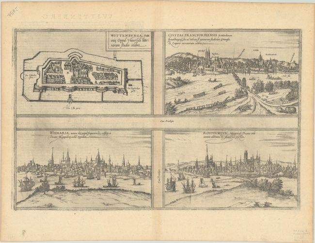
Braun & Hogenberg's Civitates Orbis Terrarum or "Cities of the World" was published between 1572 and 1617. Within the six volumes, 531 towns and cities were depicted on 363 plates, providing the reader with the pleasures of travel without the attendant discomforts. Braun wrote in the preface to the third book, "What could be more pleasant than, in one's own home far from all danger, to gaze in these books at the universal form of the earth . . . adorned with the splendor of cities and fortresses and, by looking at pictures and reading the texts accompanying them, to acquire knowledge which could scarcely be had but by long and difficult journeys?" Braun and Hogenberg incorporated an astonishing wealth of information into each scene beyond the city layout and important buildings. The plates provide an impression of the economy and prominent occupations, and illustrate local costumes, manners and customs.
This sheet includes a plan of Wittenberg and panoramic views of Frankfurt an der Oder, Wismar, and Rostock. The captions above the two bottom views are interchanged, as the left-hand view is actually of Rostock, and the right-hand view is Wismar. This is the third state of the plate, with the view of Wittenberg re-engraved as a plan. This plate was replaced with a newly engraved plate of the four cities in 1612. French text on verso.
References: Fussel, p.87; Van der Krogt (Vol. IV) #4859.
Condition: B+
A dark impression on a sheet with the coat of arms watermark of Claudon Vincent, light printer's ink residue, and minor toning along the centerfold and edges of the sheet.