Subject: Baltic Sea
Period: 1745 (circa)
Publication: Atlas van Zeevart en Koophandel door de Geheele Weereldt...
Color: Hand Color
Size:
22.3 x 19.3 inches
56.6 x 49 cm
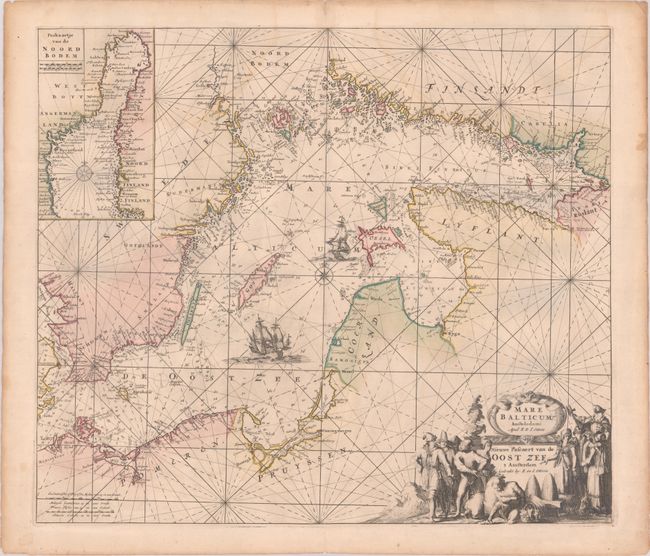
This is the rare Ottens issue of this intricately engraved chart of the Baltic Sea, which was originally published by Frederick de Wit circa 1671. It features navigational information such as soundings, anchorages, and hazards. Aside from place names along the coast, there is no inland detail. Major cities are identified in big, bold letters, including Szczecin, Gdansk, Coningsbergen (Kaliningrad), Der Memel (Klaipeda), Riga, Parnu, Revel (Tallinn), Vyborg, Aboo (Turku), and Stockholm. Rugen, Bornholm, Oland, Gotland, Oesel (Saaremaa), Dageroort (Hiiumaa), and myriad smaller islands are located. The chart is crisscrossed by rhumblines and is further decorated by two massive sailing ships and a compass rose at center. At bottom right the Latin and Dutch titles are enclosed by an elaborate figurative title cartouche featuring merchants and noblemen and women in local dress.
In 1715, Louis Renard published Atlas de la Navigation, a sea atlas consisting of plates corrected and reworked from de Wit's originals. The Ottens published a Dutch edition of the Renard atlas in 1745, and, following the general custom of the time, they erased the Renard imprint, replacing it with their own. The Ottens issue of this chart adds the inset at top left, Paskaartje van de Noord Bodem, extending coverage north to the Gulf of Bothnia. It also identifies St. Petersburg along the eastern edge of the chart.
References: Koeman, Ren 3 [9].
Condition: B+
A sharp impression in full contemporary color with light dampstaining at top. There are short archivally repaired centerfold separations at top and bottom.