Current Auction
Lot 382
Current Auction

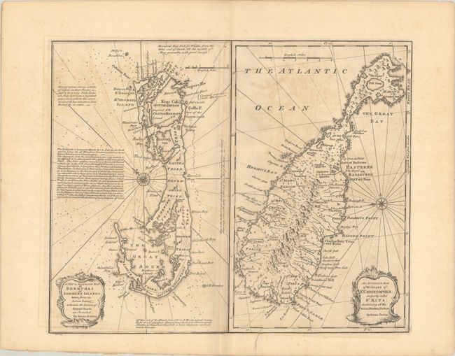
"A New & Accurate Map of Bermudas or Sommer's Islands, Taken from an Actual Survey... [on sheet with] An Accurate Map of the Island of St. Christopher, Vulgarly Called St. Kits...", Bowen, Emanuel

Subject: Bermuda & St. Kitts

Period: 1750 (circa)

Publication: A Complete System of Geography…

Color: Black & White

Size:
17.1 x 13.9 inches
43.4 x 35.3 cm
Download High Resolution Image
(or just click on image to launch the Zoom viewer)

This sheet contains maps of Bermuda and St. Kitts, each enclosed in its own borders. The map of Bermuda is oriented with northeast at the top, and depicts the roads, towns, and tribes on the island, as well as navigational hazards in the surrounding waters. There are several notes on the map giving more detail about the islands. The map of St. Kitts is oriented with east at the top and depicts numerous small towns, parishes, and the topography of the island. Each map is adorned with an baroque-style title cartouche.

References: McCorkle (18th C. Geography Books) #17-34 (Vol II); Shirley (BL Atlases) T.BOW-2a #64.

Condition: B

A dark impression with a Lubbert van Gerrevink watermark. There is offsetting and an edge tear entering 5" into map image at bottom that has been closed on verso with old paper.

Estimate: $325 - $400

Current High Bid:
$0

Reserve: Reserve Not Met
Next Bid: $170

Bid Increments
$100 - $249$10
$250 - $499$25
$500 - $999$50
$1,000 - $2,499$100
Terms & Conditions