Subject: Bermuda
Period: 1626 (dated)
Publication: A Prospect of the Most Famous Parts of the World…
Color: Black & White
Size:
20.9 x 15.8 inches
53.1 x 40.1 cm
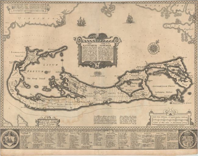
This handsome map was compiled in 1622 by Richard Norwood. It is the first English printed map published in an atlas to show Bermuda divided into Tribes and Shares. These divisions designated the properties given to the 'Adventurers,' led by Sir George Sommers, who were shipwrecked there in 1609. Speed's map became the standard map of the 17th century and was copied by Blaeu, Jansson, Ogilby, and others. The title is in both English and Latin. The map was beautifully engraved by Abraham Goos in Amsterdam for Speed's Prospect, and his imprint appears below the scale of miles. This edition has the imprint of George Humble at left, published between 1627-32. The map is embellished with sailing ships, a compass rose, four cartouches, and two coats of arms. English text on verso (pp. 41-42) and accompanied by an extra sheet of related text (pp. 43-44).
References: Palmer (MCC-19) #2; Shirley (BL Atlases) #T-SPE-2a #21.
Condition: B
A crisp impression on paper with a bunch of grapes watermark. The sheet has been trimmed to the border at left and right and inside the border at top with minute loss of image. There is a light dampstain at lower left.