Subject: Tierra del Fuego
Period: 1784 (published)
Publication: A New, Authentic, and Complete Collection of Voyages Around the World
Color: Black & White
Size:
13.4 x 7.3 inches
34 x 18.5 cm
Captain James Cook (1728-1779) is best known for his three voyages to the Pacific (1768-71; 1772-75; and 1776-79). His discoveries radically changed the western understanding of the world in the late 18th century. He was the first to circumnavigate and chart New Zealand and provided the earliest European accounts of exploration along the eastern coast of Australia and the Hawaiian Islands. On February 14th, 1779, he was killed on Hawaii after attempting to kidnap the chief of the island.
Many contemporary accounts of Cook’s voyages, including charts and engravings, appeared in the late 18th century. The first official account of Cook’s first voyage was published in 1773 by John Hawkesworth in Volumes II and III of An Account of the Voyages Undertaken by the Order of His Present Majesty for Making Discoveries in the Southern Hemisphere... William Strahan and Thomas Cadell published the first official accounts of the second and third voyages in 1777 and 1784. Accounts of his exploration were subsequently translated into French, German, and Dutch.
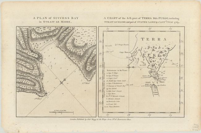
This sheet contains two charts in the lower half beneath four coastal perspectives. The Tierra del Fuego chart (at right) depicts the tract of the Endeavor as Capt. Cook traveled from east to west between January 11th - 27th, 1769. A lettered key locates and names 14 places on the views above. The plan of Success Bay (at left) shows great detail including soundings, anchorage, and a compass rose and features a surprising amount of inland detail. Both charts have their own border. This early Cook exploration map is from his first voyage.
References: Shirley (BL Atlases) G.AND-1a #13.1 & 13.2.
Condition: B+
A crisp impression with very light toning and an extraneous vertical crease.