Subject: Charleston, South Carolina
Period: 1861 (dated)
Publication:
Color: Black & White
Size:
24.3 x 35.9 inches
61.7 x 91.2 cm
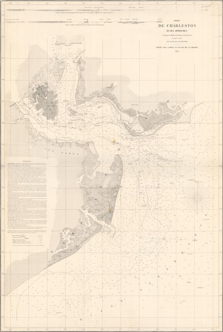
This scarce French chart was issued at the onset of the Civil War. It was based upon an earlier U.S. Coast Survey chart published in 1855 under the direction of A.D. Bache. The chart extends from Sullivan's Island south to Folly Island, with extensive detail of Charleston Harbor and further inland to the confluence of the Cooper and Wando Rivers and part of the Ashley River. Above Fort Sumter is the "Rade de la Rebellion" (Rebellion Road). This water was historically a place of safe anchorage, but during the Civil War confederate forces would fill the area with mines to ward off Union ships. The chart presents the detailed street grid plan and docks of Charleston and locates forts Moutrie, Sumter and Johnson. The surrounding waters are filled with soundings, ground types, channels, hazards, lighthouses and more along with excellent coastal features. The chart is completed by two approach views at top and sailing directions at left. We found no past sales records for this map and only one institutional example on OCLC (British Library).
References:
Condition: B
Trimmed to the neatline on all sides with archival repairs to 3" edge tears at both top and bottom. There are a few other short edge tears and a manuscript notation in the top right corner.