Subject: Florida
Period: 1890 (dated)
Publication:
Color: Printed Color
Size:
15.5 x 31.4 inches
39.4 x 79.8 cm
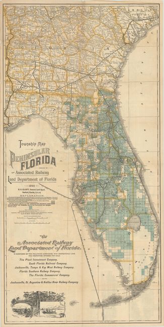
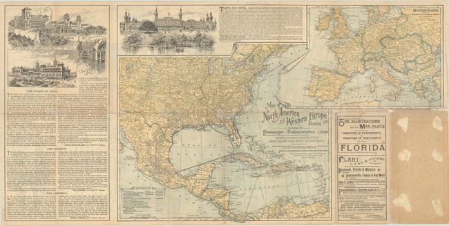
This scarce map of the state by D.H. Elliot, General Land Agent, was issued by the Associated Railway Land Department of Florida, a consortium of companies with land for sale on the peninsula. The lands for sale are indicated by green squares representing 20 statute miles. The map reflects the influence of Henry B. Plant, the businessman behind the Plant System of southern railroads and steamships. Indeed, all of the companies named as part of the Associated Railway Land Department of Florida were owned by Plant. Competing with railroad magnate Henry Flagler, who built up Florida's east coast, Plant extended his railroad across the state, connecting east and west with his line running from Sanford to Tampa. The map extends to include part of Georgia and South Carolina, spanning as far north as Charleston. A vignette at bottom left shows quail hunting and tarpon fishing. On verso is another map, Map of North America and Western Europe Showing the Direct Passenger - Transportation - Lines Between Europe and the United States, Mexico, the West Indies, Central and South America... (23.3 x 15.7") showing the travel between the continents possible because of Plant. There are also vignettes of hotels, including the crown jewel of Plant's Florida project, the Tampa Bay Hotel. Plant built this sumptuous hotel at the end of his rail line; it is now the Henry B. Plant Museum, highlighting Gilded Age tourism in the region. Printed by Matthews, Northrup & Co.
References: Rumsey #4100.
Condition: B+
Issued folding, now flat, with a hint of toning along the folds and archival repairs to several short fold separations on verso.