Subject: Colonial Southern & Central United States
Period: 1757 (dated)
Publication: Histoire Generale des Voyages
Color: Hand Color
Size:
11.9 x 8.8 inches
30.2 x 22.4 cm
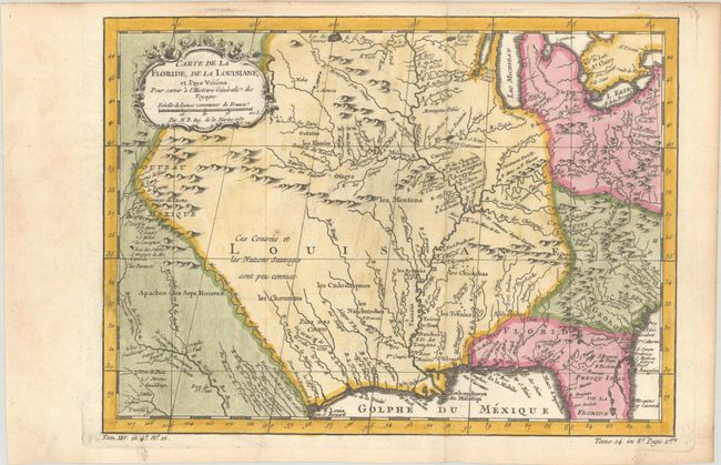
This finely engraved French and Indian War period map of French Louisiana is based on a map by Delisle. It covers from the Great Lakes to the Gulf of Mexico, extending to show Nouveau Mexique in the west and about half of Florida in the southeast. The Mississippi River flows dramatically down the center of the map with tributaries including l'Oyo ou la Belle Riviere (the Ohio River), Missouri River, and the Riviere de Moingona in the area of modern-day Des Moines. The map is filled with place names including many Indian tribes, missions, forts, and early settlements. Nouveau Mexique in the far west includes Santa Fe and names the S. Jerome de Taos. Adorned with a rococo-style title cartouche with a distance scale.
References:
Condition: B+
A dark impression, issued folding, on a watermarked sheet with a small spot and light printer's ink residue. There is light toning along the sheet edges.