Subject: Colonial Northeastern United States & Canada, Great Lakes
Period: 1755 (dated)
Publication: Atlas Universel
Color: Hand Color
Size:
23.8 x 19 inches
60.5 x 48.3 cm
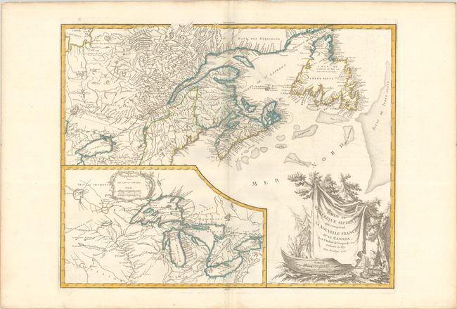
This is a handsome map of Newfoundland, Nova Scotia, and the entire course of the St. Lawrence River. The most prominent feature of the map is the very large inset of the 1744 Bellin version of the Great Lakes. The wonderful cartouche features the title on a blanket draped over a wooden canoe, which appears beside a threatening beaver. This is the third state of the map, which underwent numerous changes. A dashed line was added surrounding the Province of Quebec, and Nouvelle Ecosse was added in Nova Scotia. The northern boundary of New York was eliminated, and the boundary of New England was extended north to include most of present-day Maine. A dashed boundary was added south of Lake Ontario to represent the 1768 Treaty of Fort Stanwix. Dated 1755 but published circa 1768.
References: Karpinski pp.141-42; Kershaw #356; McCorckle #755.36; Pedley #459; Sellers and Van Ee #61.
Condition: A
A crisp impression on watermarked paper with a hint of offsetting.