Subject: Britain
Period: 1697 (circa)
Publication:
Color: Hand Color
Size:
34.8 x 21.7 inches
88.4 x 55.1 cm
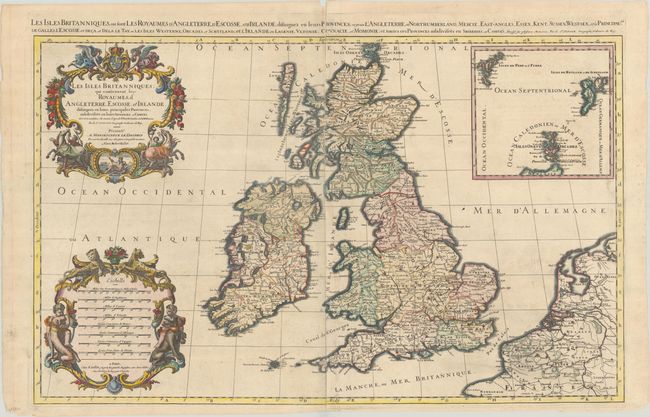
This is considered one of the most attractive maps of the British Isles of the late 17th century. The map was created by Jaillot, who was the successor to the Sanson publishing family. The map follows the geography of Nicolas Sanson, who is credited in the title cartouche along with Charles Saxton, John Speed, and Timothy Pont, among others. Britain is shown in fine detail with hundreds of place names in this finely engraved map. The map has two stunning baroque cartouches featuring Neptune, angels, horses with their handlers, and cherubs with large dogs. A large inset details the Shetland, Faroe and Orkney Islands. This is the second plate, fourth state with the date removed. An alternate French title appears above the map: "Les Isles Britanniques, ou Sont les Royaumes d'Angleterre, d'Ecosse, et d'Irlande; Distingues en leurs Provinces..." Printed on two sheets, joined as issued.
References: Shirley (BI to 1750) Jaillot 1, Plate 2.4.
Condition: B+
A dark impression with contemporary color in the map and later color in the cartouche, on a bright sheet with light soiling and a couple of small abrasions along the centerfold at bottom. There are archival repairs to several separations along the centerfold and to three short edge tears. There is a small chip at top center, well away from the image.