Catalog Archive
Auction 206, Lot 297
"[Lot of 4] Map of the Upper Geyser Basin Yellowstone National Park... [and] Map of the Lower Geyser Basin... [and] Map of the White Mountain or Mammoth Hot Springs on Gardiners River... [and] Map of the Shoshone Geyser Basin West End of Shoshone Lake...", Hayden, Ferdinand Vandeveer
Subject: Yellowstone, Wyoming
Period: 1878 (dated)
Publication: Hayden's 12th Annual Report
Color: Black & White
Size:
See Description
Download High Resolution Image
(or just click on image to launch the Zoom viewer)
(or just click on image to launch the Zoom viewer)
This lot features four maps from Ferdinand Vandeveer Hayden's (1883). It was the second volume of the twelfth and final report of Hayden's survey of the West, focusing specifically on Yellowstone. Plotted by Henry Gannett from notes and sketches by J.E. Mushbach, these maps feature extraordinary detail of Yellowstone's topography.
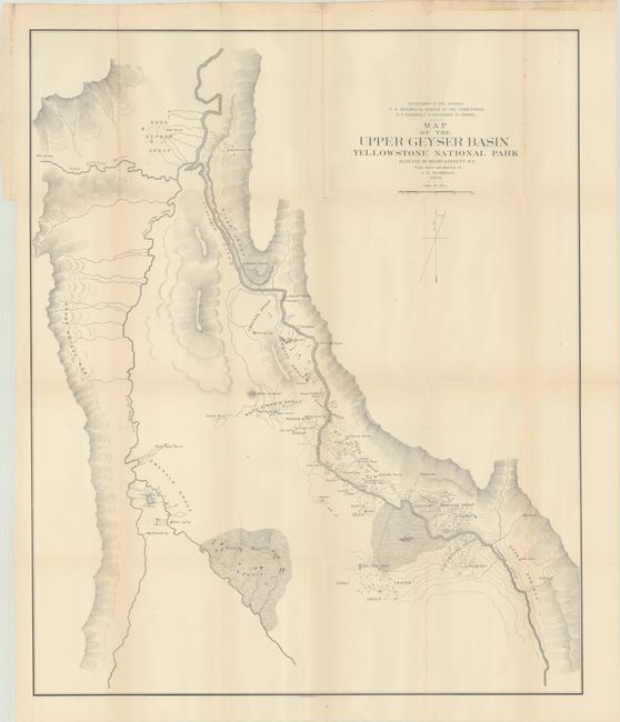
A. Map of the Upper Geyser Basin Yellowstone National Park..., (23.9 x 28.9"). This map shows excellent detail of the geysers and hydrothermal features of the Upper Geyser Basin, including Old Faithful. Condition: On a clean sheet with a few tiny separations at the fold intersections. (A)
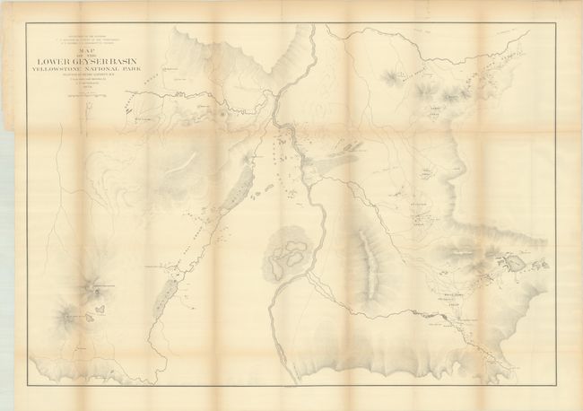
B. Map of the Lower Geyser Basin..., (34.8 x 24.0"). This map traces the FIrehole River and related creeks, lakes, and geysers. Condition: There is light toning along the folds and several short separations at the fold intersections. There is a binding tear that enters 0.5" into map image at left and a small tear in the Fairy Falls Group that have both been closed with archival tape on verso. (B+)
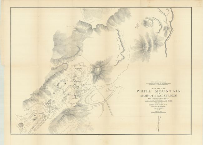
C. Map of the White Mountain or Mammoth Hot Springs on Gardiners River..., (24.0 x 17.0"). The map presents good detail of the Mammoth Hot Springs regionand locates the Main Springs, Sulphur Spring, Cleopatra Spring, and bath houses. It shows a planned road just to the west of Lookout Hill, and the Gardiner River is delineated farther to the east. Condition: On a clean sheet with minor offsetting. (A)
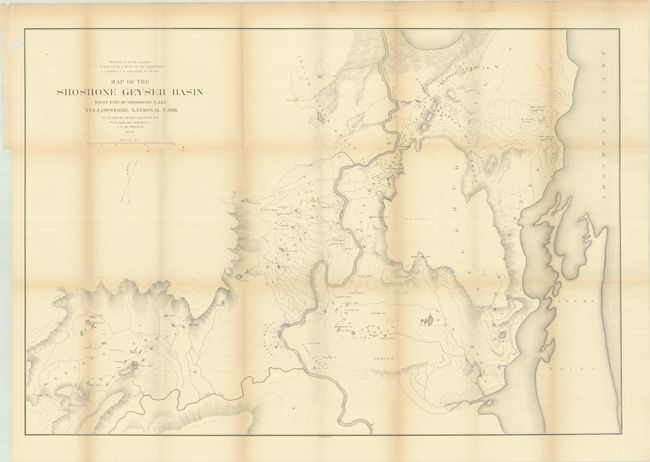
D. Map of the Shoshone Geyser Basin West End of Shoshone Lake..., (34.9 x 23.9"). This map explores the watershed along Shoshone Creek, centering on Minute Man Geyser and delineating the westernmost shore of Shoshone Lake at right. Condition: There is light toning along the folds, several short separations at fold intersections, and a few light spots. An archivally repaired binding tear enters 2" into map image at top left, and a chip in the top left margin just touches the neatline. (B+)
A. Map of the Upper Geyser Basin Yellowstone National Park..., (23.9 x 28.9"). This map shows excellent detail of the geysers and hydrothermal features of the Upper Geyser Basin, including Old Faithful. Condition: On a clean sheet with a few tiny separations at the fold intersections. (A)
B. Map of the Lower Geyser Basin..., (34.8 x 24.0"). This map traces the FIrehole River and related creeks, lakes, and geysers. Condition: There is light toning along the folds and several short separations at the fold intersections. There is a binding tear that enters 0.5" into map image at left and a small tear in the Fairy Falls Group that have both been closed with archival tape on verso. (B+)
C. Map of the White Mountain or Mammoth Hot Springs on Gardiners River..., (24.0 x 17.0"). The map presents good detail of the Mammoth Hot Springs regionand locates the Main Springs, Sulphur Spring, Cleopatra Spring, and bath houses. It shows a planned road just to the west of Lookout Hill, and the Gardiner River is delineated farther to the east. Condition: On a clean sheet with minor offsetting. (A)
D. Map of the Shoshone Geyser Basin West End of Shoshone Lake..., (34.9 x 23.9"). This map explores the watershed along Shoshone Creek, centering on Minute Man Geyser and delineating the westernmost shore of Shoshone Lake at right. Condition: There is light toning along the folds, several short separations at fold intersections, and a few light spots. An archivally repaired binding tear enters 2" into map image at top left, and a chip in the top left margin just touches the neatline. (B+)