Subject: New York, United States
Period: 1939 (circa)
Publication:
Color: Printed Color
Size:
16.1 x 11.6 inches
40.9 x 29.5 cm
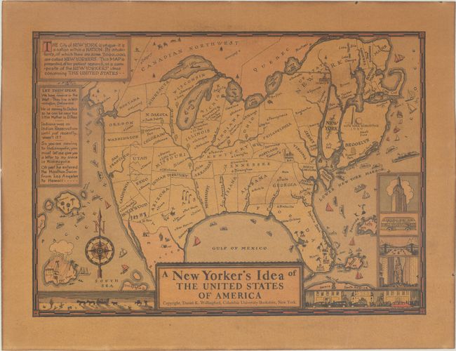
New Yorkers are known to have great pride in their city, and this humorous map perhaps best demonstrates a New Yorker's perspective of the United States, with Manhattan, Long Island, and Staten Island dominating the eastern seaboard. New York is shown as the largest state in the US, with Long Island itself depicted larger than both California and Texas. All of the states are distorted and a number of states and cities are mis-located, as they clearly are not important enough for a New Yorker to know exactly where they are. The state of Pennsylvania is called Philadelphia, with Pennsylvania noted as a city in the northwest of the state. New Orleans is shown in Florida, Louisiana and Mississippi are inverted, and Minneapolis and Indianapolis are noted as "Twin Cities" within Michigan. The text at top left states that the city of New York is "a nation within a nation" with 7 million inhabitants. Several decorative vignettes fill the borders of the map with images of a cityscape, the Empire State Building, and a Fifth Avenue Coach bus to the east, while a stagecoach and donkey cross the desert to the west. Created by Daniel K. Wallingford. There were several different editions of this map, this being a larger version including the World's Fair grounds on Long Island. Blank verso. Published by the Columbia University Bookstore.
References: Hornsby (Picturing America) pp. 58-59 & plate 9.
Condition: B
Moderate toning on glossy paper.