Current Auction
Lot 111
Current Auction

Striking Map of Colonial America with Bison Vignette

"Amplissimae Regionis Mississipi seu Provinciae Ludovicianae a R.P. Ludovico Hennepin Francisc Miss. in America Septentrionali Anno 1687...", Homann, Johann Baptist

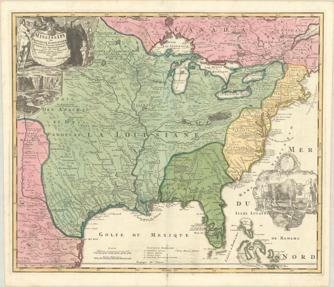
Subject: Colonial Eastern United States & Canada

Period: 1720 (circa)

Publication:

Color: Hand Color

Size:
22.8 x 19.2 inches
57.9 x 48.8 cm
Download High Resolution Image
(or just click on image to launch the Zoom viewer)

A striking map based on Delisle's landmark map of 1718, but covering a slightly larger area. It focuses on the Mississippi River Valley interior and Great Lakes, also detailing the Gulf Coast region, where the Mission de los Teyas is noted in present-day Texas. The map is splendidly adorned by vignettes of a bison and Native Americans in a cartouche filling the Atlantic, and a beaver colony at Niagara Falls under the title cartouche at upper left. Also depicted in the title cartouche is Father Louis Hennepin who explored the Great Lakes region and claimed to have reached the mouth of the Mississippi. The routes of Hennepin, de Soto and other explorers are traced in the map.

See also lot 737 for John Goss' The Mapping of North America - Three Centuries of Map-Making 1500-1860 that describes this map.

References: McCorkle #720.1; Goss (NA) #49; cf. Wheat (TMW) #144; cf. Cumming (SE) #170.

Condition: A

A crisp impression with full contemporary color. There is some minor printer's ink residue along the lower centerfold.

Estimate: $2,200 - $2,500

Current High Bid:
$1,600

Reserve: Reserve Met
Next Bid: $1,700

Bid Increments
$1,000 - $2,499$100
$2,500 - $4,999$250
$5,000 - $9,999$500
$10,000 - $24,999$1,000
Terms & Conditions