Subject: Western United States & Mexico, San Francisco
Period: 1855 (published)
Publication:
Color: Black & White
Size:
19.4 x 15.4 inches
49.3 x 39.1 cm
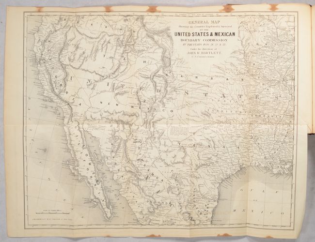
This important foldout map is bound into The Annals of San Francisco; Containing a Summary of the History of the First Discovery, Settlement, Progress & Present Condition of California, and a Complete History of All Important Events Connected With Its Great City.... by Francois ("Frank") Soule, John H. Gihon, M.D., and James Nisbet. The map covers the entire West from the Mississippi River with particular emphasis on the land recently obtained from Mexico and is filled with place names, numerous Indian villages and geographical notations. Wheat notes that this is, all in all, an excellent map of the West that has a very early depiction of the Gadsden Purchase. It is one of the first commercial maps to show Jackson Lake, here named Sublettes L., east of the three Tetons. The geography of the unnamed Great Basin follows closely the cartography of Fremont's maps of 1845 and 1848. Utah is in its largest configuration stretching between California and east beyond the Continental Divide to Kansas. Place names include Mormon Sett. in Utah, Franklin opposite of El Paso, and numerous New Mexican settlements. The routes of severak explorers are identified. The map extends to include all of the Baja. Map published by J.H. Colton & Co.
The book has 824 pages, six engraved plates, including two views of San Francisco, 142 illustrations, and two maps, the one previously mentioned, and a single-page map of San Francisco. Published by D. Appleton and Co., New York, San Francisco, and London. Hardbound in brown cloth with gilt title on spine and the Seal of California on cover. Octavo.
References: Wheat (TMW) #798; Wagner-Camp #234:1; Howes #S-769.
Condition: B
The large folding map is very good with a 2.5" binding tear at right that has been closed on verso with archival tape, minor offsetting, and moderate staining in the top and bottom margins that just barely crosses into map image. Text is lightly toned with occasional foxing, although the plates, title page, and endpapers are all lightly to moderately foxed. The first 12 pages including the table of contents is loose. Front cover was loose and reattached with binder's tape. Covers are worn and the spine is sunned.