Subject: Wyoming
Period: 1875 (published)
Publication:
Color: Printed Color
Size:
17.9 x 31 inches
45.5 x 78.7 cm
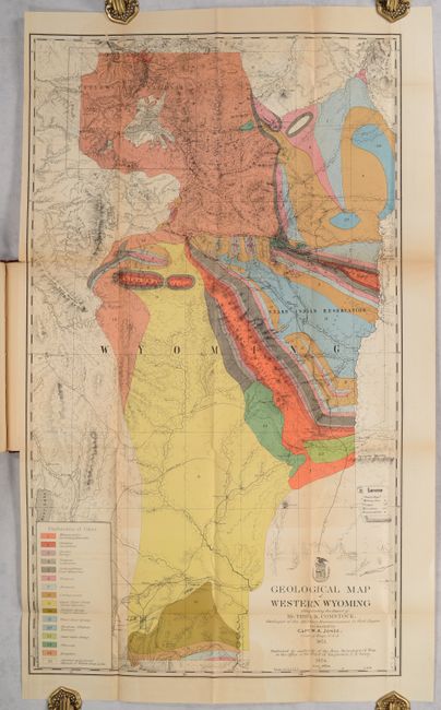
This handsome and colorful map illustrated the report of T.B. Comstock, the geologist to the Military Reconnaissance of the region that was conducted by Capt. W.A. Jones, Corps of Engineers. This is one of the earliest geological maps of Yellowstone country based on actual exploration, preceded only by Hayden's very rare separately published maps of Montana and Wyoming territories and the Snake River (Marcou & Marcou #629 & #630). The chart shows 15 classes of geology, the topography, and trails in the northwestern part of Wyoming, including roads, stage stations, military posts, astronomical observation stations, and boundaries of the Snake Indian Reservation. The area covered includes Jackson Hole and the Big Horn and Teton mountains, and extends south to Fort Bridger and the Sweetwater Mountains. There is terrific detail of the newly formed Yellowstone Park.
The map is bound into the original report (6.1 x 9.3") which also includes Map of a Military Reconnoissance of North Western Wyoming (30.3 x 17.3") and 49 untitled maps which show the route of the reconnaissance. 331 pages, plus index and maps. 8vo, hardbound in maroon pebbled cloth.
References: Marcou & Marcou #631; Blevins Mapping Wyoming #256.
Condition: B
The vividly colored geological map has a few short fold separations, light offsetting, and light toning along the folds. The "Map of a Military Reconnoissance of North Western Wyoming" is present in the volume but perished along the folds. The other untitled maps are good to very good with light toning and an occasional fold separation. Text is clean and faintly toned. Hinges are starting and there is light shelf wear on the covers.