Subject: Central Colorado, Denver
Period: 1877 (dated)
Publication: U.S. Geographical Surveys West of the 100th Meridian
Color: Black & White
Size:
19.1 x 15.1 inches
48.5 x 38.4 cm
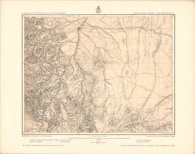
The 1870s was a period of intense effort, by such prominent people as Clarence King, Ferdinand Hayden, and John Wesley Powell, to advance the geographical knowledge of the West. These various surveys presented a threat to the Army's supremacy in the field of mapping and to the related appropriations from Congress. As a result of these pressures, the Army Corp of Engineers developed a plan to systematically survey the entire West to be called the U.S. Geographical Surveys West of the One Hundredth Meridian. The region was divided up into 95 rectangles, with atlas sheets to be prepared for each, comprising an area 2°45' of longitude and 1°40' of latitude on a scale of eight miles to the inch. Lieutenant George Wheeler was chosen to head this immense project. Surveys were conducted each summer from 1872 to 1878, after which Congress cut off appropriations for field work; thus the survey was not completed as originally envisioned. Wheeler published annual reports from 1873 to 1884, as well as the final Geographical Report published in 1889. The maps from this report are a valuable document of the record of Western exploration.
This map covers central Colorado and the drainage basin of the South Platte River with Denver at top. It provides excellent detail of the topography, roads, rivers, springs, railroads, mills, mines, and quarries. Railroad lines shown include the Colorado Central, the Denver & Rio Grande, the Kansas Pacific, and the Denver Pacific. In addition to Denver, the map shows the settlements of Golden, Littleton, Castle Rock, Franktown, Larkspur, and several others that are no longer in existence. Based upon surveys taken in 1873 and 1876. On a detailed scale of 4 miles per inch.
References: Phillips (Atlases) #1281-68.
Condition: A
A crisp impression on a clean sturdy sheet.