Subject: World
Period: 1761 (dated)
Publication: Dictionnaire Geographique Portatif
Color: Hand Color
Size:
13.1 x 8.7 inches
33.3 x 22.1 cm
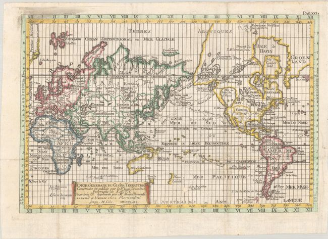
This uncommon map is a re-engraved edition of Remondini's reduction of Isaak Brouckner's map of the world. It features an extravagant collection of Northwest Passage theories, including one based on the infamous expedition by Admiral Bartholomew de Fonte. In 1708, a newly discovered account of the Spanish Admiral's 1640 discovery of the passage was published. That account was actually a journalistic hoax, but thereafter the account was changed and elaborated upon by numerous mapmakers. This map shows one Northwest Passage from Baffin Bay to exit at roughly Alaska, and another from the St. Lawrence through the Great Lakes and out via the massive and utterly spurious Sea of the West (Mer ou Baie de l'Ouest). The large fictional lakes from De Fonte's account include Velasco, de Fonte, and the strange archipelago of St. Lazare. In the North Pacific, the routes of the Russian expeditions and the Manilla/Alcapulco galleons are charted. In the South Pacific, the partial coastlines of Australia and New Guinea are shown connected, and both New Zealand and Tasmania are shown as single coastlines. The map is engraved in an unusual and simple style, and titled on a banner style cartouche. This is the third edition of the map as identified by McGuirk, with "chez Remondini" after the title and the date 1761.
Isaak Brouckner's influential world map was produced on twelve sheets and published as the Nouvel Atlas de Marine in 1749. This was the first Prussian marine atlas prepared under the direction of the Academy of Sciences in Berlin. The Academy's considerable archives were used by Brouckner to compile the map. This map was a principal source of information for late 18th century cartographers, particularly for the depictions of the northwest coast of America. The large 12-sheet map is extremely rare.
References: McGuirk #52.
Condition: B+
Issued folding, now flat, with faint dampstaining at top, a couple tiny wormtracks, and a 0.5" abrasion to the southeast of New Zealand. A couple tiny chips around a fold at bottom right have been infilled with archival materials.