Subject: United States, Franklin
Period: 1812 (published)
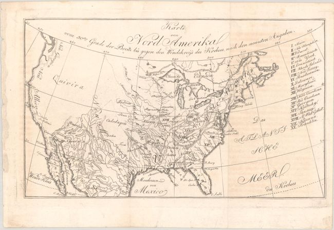
Publication: Die Erde und ihre Bewohner nach den Neuesten Entdekkungen...
Color: Black & White
Size:
10.7 x 6.4 inches
27.2 x 16.3 cm
This is the first state of this small map that was first published in Zimmerman's Taschenbuch der Reisen, oder Unterhaltende Darstellung der Entdeckungen des 18ten Jahrhunderts. The volume was the fourth title in Zimmerman's annual compilations, and is devoted entirely to America. The map itself covers the entire present-day United States and lists twenty states in a table at right including the short-lived state of Franklin, which is erroneously identified in present-day Ohio. Topography and drainage is emphasized in this map with only a few place names west of the Missouri River, including a large Quivira in the Great Basin and Neu Albion along the west coast. This scarce issue was published in Die Erde und ihre Bewohner nach den Neuesten Entdekkungen... (1812) and is distinguished by its heavier paper stock. It is likely that an overrun of the first state was printed and stored and then used for the 1812 book.
References: Dotson & Baker (OWA) #21.1.
Condition: B+
Issued folding with light offsetting from an opposing page of text that is visible at right and far left.