Subject: Colonial Northeastern United States & Canada
Period: 1772 (dated)
Publication: Reis door Noord Amerika
Color: Black & White
Size:
29.9 x 22.1 inches
75.9 x 56.1 cm
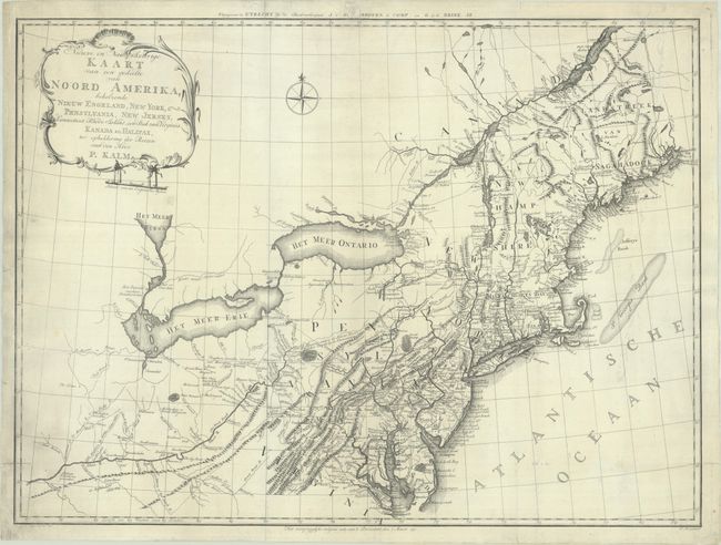
This scarce map, largely based upon Lewis Evans' 1755 map, covers Virginia through New England, the St. Lawrence River, Lake Ontario and Lake Erie and extends west to the confluence of the Ohio and Kentucky rivers. The map is filled with detail of the colonies, as well as settlements, forts (including Fort Detroit), and Indian villages west of the Ohio River. There is great detail of the Swedish settlements, particularly along the Delaware River and in southern New Jersey. There are several interesting notations such as where to locate coal, salt and whetstones, and the place where elephant bones were found along the Ohio River. The map is among the earliest maps to identify Petroleum in western Pennsylvania, near present-day Titusville where the first oil well was drilled nearly a century later.
The map was issued to illustrate Peter Kalm's book of his travels and adventures in the region. Kalm’s work is one of the most important and reliable eighteenth-century accounts of American natural history, social organization, and political situation. It also provides important accounts of the American Swedish settlements. This is the more decorative and rare Dutch version, engraved by Carel Jacob de Huyser.
References: McCorkle #772.3; Seller & Van Ee #727; Howes #K-5.
Condition: B+
A dark impression, issued folding and now flattened and backed with tissue to repair a small tear and a few separations along the edges. There is some light soiling along the left edge and a small chip in the top margin with minor loss of publisher's imprint.