Subject: Colonial Eastern North America & West Indies
Period: 1780 (circa)
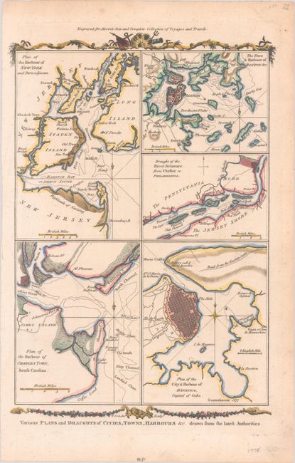
Publication: Moore's New and Complete Collection of Voyages and Travels
Color: Hand Color
Size:
8.3 x 11.8 inches
21.1 x 30 cm
This very attractive sheet has five maps: Plan of the Harbour of New-York and Parts Adjacent, The Town & Harbour of Boston &c., Draught of the River Delaware from Chester to Philadelphia, Plan of the Harbour of Charles Town, South Carolina, and Plan of the City & Harbour of Havana, Capital of Cuba. Each map is very detailed with city plans, islands, and channels. Filled with interesting and early place names: Old Town and New Town on Staten Island, Elizabeth Town, Penny Ferry, Inn de Marmoleno, Johnstons Fort, etc. Top and bottom have decorative garlands.
References: Shirley (BL Atlases) G.MOOR-1a #8.
Condition: A
A nice impression on a sheet with a hint of toning, later color including some gold highlights, and a tiny tear at bottom right that has been closed on verso with archival tape. There are small remnants of hinge tape on verso.